| Table 2. Data record and their descriptions. ETRS-TM35FIN (EPSG:3067) is a projected coordinate reference system (CRS) commonly used in Finland. N2000 is the used vertical reference system. Tree species distribution is presented for tree attributes. For stand-level forest inventory attributes, the minimum–maximum ranges as well as mean values (in parenthesis) across the sample plots is presented. |
| Data record | Description | Data format |
| Tree-segmented point cloud data | A point cloud file (one per each sample plot) containing the following attributes for each point record: | .laz (version 1.4) |
| - X coordinate (Easting) [m], ETRS-TM35FIN (epsg: 3067) |
| - Y coordinate (Northing) [m], ETRS-TM35FIN (epsg: 3067) |
| - Z coordinate (Height) [m], N2000 |
| - Reflectance (distance-corrected intensity) [dB] (stored as Extra Field) |
| - Return number |
| - Number of returns |
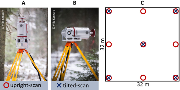
| - Scan position ID (stored as Point Source ID) |
| - Height above ground level [m] (stored as Extra Field ‘h’) |
| - Tree ID number (stored as Extra Field ‘treeid’) |
| Tree attributes | A text file containing the following attributes for each tree segmented, in the order of their appearance: | .csv (comma delimited) |
| - x: X coordinate of stem cross section mid-point (Easting) [m], ETRS-TM35FIN (epsg: 3067) |
| - y: Y coordinate of stem cross section mid-point (Northing) [m], ETRS-TM35FIN (epsg: 3067) |
| - z: Z coordinate of stem cross section height [m], N2000 |
| - plot_id: Sample plot ID number |
| - tree_id: Tree ID number |
| - tree_sp: Tree species: | n |
| 0 = not defined | 1882 |
| 1 = Scots pine (Pinus sylvestris L.) | 1811 |
| 2 = Norway spruce (Picea abies (L.) H. Karst.) | 1415 |
| 3 = Birches (Betula L. spp.) | 989 |
| 4 = European aspen (Populus tremula L.) | 71 |
| 5 = grey alder (Alnus incana (L.) Moench) | 44 |
| 6 = common alder (Alnus glutinosa (L.) Gaertn.) | 1 |
| 7 = rowan (Sorbus aucuparia L.) | 68 |
| 9 = Larix spp. | 1 |
| 10 = Fir (Abies spp.) | 6 |
| 11 = unknown species | 29 |
| 12 = common juniper (Juniperus communis L.) | 3 |
| - stem_diam: Stem diameter at the height of tree identification [m] |
| - tree_height: Tree height [m] |
| - crown_area: Crown projection area [m2] |
| - crown_diam: Crown diameter [m] |
| - circle_compl: Circle completeness [%] (related to Hough circle finding) |
| - goodness_of_fit: Goodness of fit [%] (related to Hough circle finding) |
| - pts_on_circle: n.o. points on the fitted circle (related to Hough circle finding) |
| - slice_height: point cloud slicing height (± 0.15 m) for tree identification |
| Forest inventory attributes | A text file containing stand-level forest inventory attributes for each sample plot, in the order of their appearance in the file: | .csv (comma delimited) |
| - plot_id: Sample plot ID number |
| - x: X coordinate of sample plot center (Easting) [m], ETRS-TM35FIN (epsg: 3067) |
| - y: Y coordinate of sample plot center (Northing) [m], ETRS-TM35FIN (epsg: 3067) |
| | min–max (mean) |
| - N: number of trees per hectare | 166–2080 (697) |
| - G: mean basal area [m2/ha] | 4.9–50.9 (30.2) |
| - V: total stem volume [m3/ha] | 40.9–625.1 (324.0) |
| - Dg: basal area-weighted mean diameter [cm] | 16.9–45.2 (28.7) |
| - Hg: basal area-weighted mean height [m] | 11.8–31.5 (22.1) |
| - Pine_BA%: Scots pine basal area perc. [%] | 0–99.9 (55.5) |
| - Spruce_BA%: Norway spruce basal area perc. [%] | 0–100 (26.7) |
| - Birch_BA%: Deciduous trees basal area perc. [%] | 0–99.3 (17.8) |