Olli-Pekka Tikkanen  ,
Irina A. Chernyakova
,
Irina A. Chernyakova
Past human population history affects current forest landscape structure of Vodlozero National Park, Northwest Russia
Tikkanen O.-P., Chernyakova I. A. (2014). Past human population history affects current forest landscape structure of Vodlozero National Park, Northwest Russia. Silva Fennica vol. 48 no. 4 article id 1207. https://doi.org/10.14214/sf.1207
Highlights
- In large scale (0–20 km), the proportion of spruce in forest stands was positively affected by distance from old villages. This relationship was non-linear with a threshold distance of 15 km
- In small scale (0–5 km), old villages affected tree species composition and age structure of forests. Effect on age structure was the strongest on stands growing on mineral soils.
Abstract
The information about location and size of past human settlements can give new insights into the analysis of landscape structures. Vodlozero National Park (NP) is one the largest strictly protected areas in Northwestern Europe. We mapped the location of historic villages, which were abandoned in 1958, and studied the effect of past human activity in the forest landscape in two different scales using forest survey data. We assessed the possible change in age, volume and tree species composition from the edge of open fields up to the distance of 5 km from villages. We made a larger landscape analysis using a grid of forest stands covering the whole northern part of the NP. The past human activity was clearly visible in the present forest landscape. Distance from villages affected age, volume and tree species composition of the forest stands. This effect was the strongest within the first two kilometers from the villages. At the level of whole northern NP, the proportion of spruce markedly increased after approximately 15 km from the nearest old village. The changes in the forests surrounding the villages were most likely the result of the intensive use of wood for different commodities needed in households and farming, in addition to short rotation slash and burn agriculture. If the occurrence of forest fires was more frequent closer to villages than in more remote areas, it can well explain the observed pattern in the abundance of spruce in the larger landscape that is less tolerant to fire than pine.
Keywords
boreal forests;
forest fires;
recovery;
forest structure;
landscape change
-
Tikkanen,
Department of Biology, University of Eastern Finland, P.O. Box 111, FI-80101 Joensuu, Finland (Current: School of Forest Sciences, University of Eastern Finland, P.O. Box 111, FI-80101 Joensuu, Finland) & Interdisciplinary Research and Educational Center of Cross-border Communication CARELICA, Institute of History, Political and Social Sciences, Petrozavodsk State University, 33 Lenin Prospectus, 185910 Petrozavodsk, Republic of Karelia, Russia
E-mail
Olli-Pekka.Tikkanen@uef.fi
- Chernyakova, Interdisciplinary Research and Educational Center of Cross-border Communication CARELICA, Institute of History, Political and Social Sciences, Petrozavodsk State University, 33 Lenin Prospectus, 185910 Petrozavodsk, Republic of Karelia, Russia E-mail irina.chernyakova@onego.ru
Received 11 June 2014 Accepted 28 October 2014 Published 27 November 2014
Views 159823
Available at https://doi.org/10.14214/sf.1207 | Download PDF

1 Introduction
The natural landscapes play a profound role in the preservation of biological diversity and as objects of theoretical ecosystem studies about ecosystem processes and functioning (Gu et al. 2002; Pennanen and Kuuluvainen 2002; Berglund and Jonsson 2005). Moreover, these landscapes have an important role in the development of management practices, because they can serve as the controls in the experimental search for methods of sustainable use of natural resources or restoration of altered landscapes (Fritschle 2012). Unfortunately, natural landscapes have more or less disappeared from most of the populated parts of Europe. In the south, the decline of natural landscapes initiated already after the end of the last glaciation when people started to use agriculture as the main source of their livelihood (Mithen 2003). Since then, a larger and larger proportion of the previous natural forests of Europe became transformed into cultural landscapes as agriculture spread across the north and the human population increased (Williams 2003).
In the north, in the second half of the second millennium, the slash and burn agriculture enabled the spread of farming communities to boreal taiga (Taavitsainen et al. 1998; Orrman 2003). Heath forests of southern boreal zone were largely affected by slash and burn agriculture (Heikinheimo 1915), and even in the mid boreal zone, the use of fire in agriculture has increased the fire frequency in the forest landscape (Zackrisson 1977; Lehtonen et al. 1996; Lehtonen and Kolström 2000; Pitkänen et al. 2002; Wallenius et al. 2005). The extremely high fire frequency of the 19th century was followed by the current very low fire frequency because of the end of slash and burn agriculture and active fire prevention which is still carried out (Pitkänen et al. 2002).
The growth and succession process of northern forest ecosystems is rather slow. As a consequence, historic information about past land use and human activity plays the key role when we try to explain the modern day patterns in the structure of any specific landscape and species communities within it (Östlund et al. 1997; Gerhard and Foster 2002; Bellemare et al. 2002; Lõhmus and Lõhmus 2008; Tikkanen et al. 2009). Therefore, adding the information about the location and the size of past human settlements to the data can give new insights into the analysis of landscape structures. This is particularly interesting, because of the pronounced effect of agriculture and human use of fire on boreal nature, as mentioned above. However, these kinds of studies are rarely reported, which is a bit odd, because it is well known that the local people are important agents affecting forest naturalness and the most important ones in areas where industrial loggings have been rare or totally absent.
In addition to the spread of agriculture and subsequent population growth, the economic development of urban societies and industrialization lead to the increased demand of natural resources. The opportunity to trade with natural resources, which were already diminishing in temperate Europe, was used by entrepreneurs of boreal Fennoscandia. Since the 19th century, the domestic and foreign trade of tar, timber and iron had been strongly promoted by the governments of Russia and Sweden even at the expense of the needs of local people (Rytteri 2006; Chernyakova 2014). As the demand of timber and pulp wood increased after the end of World War II, the destruction of natural landscapes spread even to remote areas which were marginal for agriculture (Lihtonen 1949; Parpola and Åberg 2009). As a result, current forest landscapes in the most parts of boreal Fennoscandia have lost their original natural age distribution and many structural elements typical to natural forests, such as multilayered canopy, dead wood and large diameter trees (Östlund et al. 1997; Linder and Östlund 1998; Fridman and Walheim 2000; Lilja and Kuuluvainen 2005; Ihalainen and Mäkelä 2009; Tikkanen et al. 2009). Only few larger areas of pristine forest landscape remain in the remote northern and eastern areas of Fennoscandia (Gromtsev 2003; Kobyakov and Jakolev 2013).
Keeping in mind the dramatic transformation of primeval landscape to modern industrial clear-cut management landscape in boreal Fennoscandia, it is no wonder that most studies dealing with naturalness of forests are focusing on small fragments of only few tens or hundreds of hectares (eg. Rouvinen and Kuuluvainen 2001; Rouvinen and Kouki 2002; Lindbladh et al. 2003; Erikson et al. 2005; Jönsson and Jonsson 2007; Josefsson et al. 2010) and the studies of larger current natural forest landscapes of over thousand hectares are rare (but see Rouvinen et al. 2002; Lilja and Kuuluvainen 2005; Wallenius et al. 2005). Another reason may be the great effort which such studies demand. Detailed measurements of one hectare may take one or several days and it may even take several hours to reach the site from the nearest road.
One option to overcome these problems when studying large landscapes is to use remote sensing data. For example, Landsat satellite images are easily available for the researchers, and these images are widely used in forest resource inventories (Syrjänen et al. 1994; Burnett et al. 2003). However, the major disadvantage is the limited level of information about the stand structure which the satellite images can deliver. The volume of living standing stock of the trees can be estimated from satellite images, but the accurate age of forests, for example, is hard to determine for stands older than 100 yrs (Mäkelä and Pekkarinen 2004).
Before developing modern remote sensing analysis, there was a long tradition (which still lives on) of forest surveys starting from the 19th century. Indeed, forest survey data has been applied successfully for studies of forest landscape transformation (Östlund et al. 1997; Linder and Östlund 1998). Practical forest surveys do not include such detailed information that can be obtained in field studies done by researches. However, they might be very useful when the resources for detailed field studies are limited. Therefore, it may be unwise to overlook them, especially if there is available inventory data.
One of the great remaining primeval European wilderness areas is located in the border of Karelian Republic and Archangelsk Region in Northwestern Russia (Gromtsev 2003). Now this area largely belongs to the Vodlozero National Park (NP). We mapped the location of historic villages and studied the effect of past human activity in the forest landscape of the Vodlozero NP in two different scales using forest survey data. Firstly, near the villages, we assessed in detail the possible change in age, volume and tree species composition from the edge of open fields up to the distance of 5 km. Secondly, using the same data set, we made a larger landscape analysis sampling forest stands in a grid, which covers the whole northern part of the NP including the most remote forests. By combining historic information about the presence of past human settlements and modern day forest structure we try to get information about the recovery rate of boreal forest ecosystems after the end of human impact.
2 Methods
2.1 Study area
Vodlozero NP is located in the eastern part of Karelian Republic and the western part of Archangelskaja Oblast, NW Russia, approximately 450 km northeast from the city of St. Petersburg. The NP was established in 1991 by the Russian Federation. The total area of the NP is 4734 km2, which makes it the largest strictly protected area in the whole NW Europe. It is composed of the watershed area of River Ileksa and the basin of Lake Vodlozero, as well as the land surrounding the lake. Lake Vodlozero is the largest lake in the NP and covers the area of 354 km2. The lakes cover total area of 528 km2 and treeless mires 2300 km2, respectively (11% and 49% of the total area of NP). The rest is boreal taiga forest, spotted with cultural landscapes around the villages.
The forests of the NP are largely spruce (Picea abies (L.) H. Karst.; 75%) dominated old growth forests on mineral and peaty soils which regenerate via gap dynamics (Gromtsev 2003; see also Kuuluvainen et al. 1998). The rest of the forests are dominated by pine (Pinus sylvestris L.) (Gromtsev 2003). These two tree species characterize the landscape. Birch (Betula pendula Roth and Betula pubescens Ehrh.) forests can be found near old villages, and aspen (Populus tremula L.) grows sporadically in mesic heath forests and in old growth stands. Black alder (Alnus glutinosa (L.) Gaertn.), gray alder (Alnus incana (L.) Moench), rowan (Sorbus aucuparia L.), bird cherry (Prunus padus L.), and goat willow (Salix caprea L.) are other common but mostly subordinate pioneer species in the forests. Larch (Larix sibirica Ledeb.) can be found here in the western most point of its natural distribution, but it is very rare.
The transition zone of southern and middle boreal zone (sensu Ahti et al. 1968; middle and northern taiga subzone according to the Russian vegetation zonation) goes through the park approximately on the parallel of 63° N. Roughly two thirds of the area of the park is south and one third is north of this parallel. The amount of annual precipitation is between 550 and 600 mm, the average temperature is +16 °C in July and –11 °C in January (Trofimov 1989). The landscape is hilly moraine plain with depositions of glacial marginal moraine ridges and eskers (Lukashov 2003). The highest point is 317 m asl in the hill range of Kryazh Veternyi Poyas in the northernmost part of the NP, and the lowest point 136 m asl in south on the surface of the Lake Vodlozero.
2.2 Human population
The oldest agricultural villages of Vodlozero NP probably date back to the end of 15th century (A.Y. Zhukov, according to Loginov 2010), or even earlier (Chernyakova 2013a). At the end of the 18th century there were over 2000 inhabitants in the southern area of current NP. Within next 100 years the size of human population had increased to 3365 people living in approximately 50 villages (Blagoveshchenski 1907). Nowadays only a few villages are populated. The only larger population centre, which still exists, is the village of Kuganavolok (appr. 400 inhabitants) in the southern part of the Lake Vodlozero. Only few people live elsewhere on the islands and shores of the lake. All villages in the more remote parts of the NP were deserted after the reorganization of collective farming in 1950’s.
In historic time, people have used fire for slash and burn agriculture regularly. Now the fire frequency is probably considerably lower than before the 1950’s. Based on the statistics of the National Park (V.Y. Dedov, pers. comm. in 2014), after 1999 there has been 3.6 fires a year (with average size of 19 ha). Most of the fires (83%) have concentrated in the southern area of the NP, where human recreational activity is the most intense. In the remote northern part of the NP in the area of Archangelskaja Oblast, since 1999 there has been 0.6 naturally ignited fires a year (with average size of 75 ha).
We used population data from the 1905 List of Populated Areas [the southern villages in Blagoveshchenski (1907) and the northern villages in Golubtsov (1907)] in order to find the population size of the villages and to calculate population density of the Northern area. The population density for southern area of the park was not calculated because its land area is only a relatively narrow stripe surrounding the L. Vodlozero, compared to the land mass of the northern part (the north-south border goes between the villages of Luza and Kalakunda; see Fig. 1). The 1905 census was selected because it is the last one before the great social and economical turmoil of Russian society that took place later in the 20th century. Therefore, this data probably best describes the relative sizes of local settlements during that historic time period when the local people influenced their environment in a traditional way (Chernyakova 2013a). We tested whether the size of villages influenced the mean age of the present forests within 5 km radius from the villages (n = 6, see below).
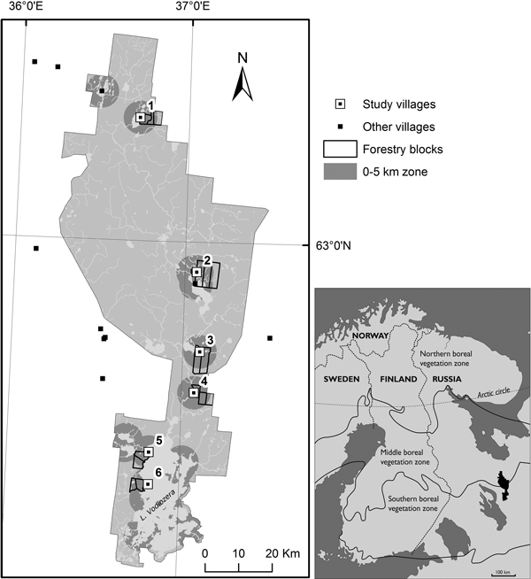
Fig. 1. The map of Vodlozero National Park and its location in the eastern Fennoscandia. The larger map shows the location of study villages and other settlements in the NP and its vicinity. The study villages were 1. Kalgatshiga, 2. Korkala, 3. Luza, 4. Kalakunda, 5. Zagorije and 6. Gumarnavolok. The study forest compartments (kvartals) indicate the location and area of sectors of the landscape, whose stand characteristics were analyzed in detail. The zone of 0 to 5 km from villages is shown with dark gray shading. The vegetation zones are according to Ahti et al. (1969).
2.3 Forestry data and the analysis
The area of National Park was surveyed after its establishment, in years 1995–1996. This survey included the mapping of vegetation types and forest stand characteristics, such as the species, age, diameter, height and volume of trees in different canopy layers. The field measurements of this survey were conducted using the standard procedures (see Ministry of Natural Resources 2008). Further on, the forest survey data was stored in a geographical information system (GIS) database.
First, for our study, we selected six old villages that were located in more or less continuous forested landscape. We did not include villages on islands, peninsulas or at the edges of large open mires, because large proportion of non-forested areas just near the villages strongly limit the availability of forest resources of villagers. Instead, our attempt was to find villages which had a relatively unlimited access to surrounding forest recourses just from the edge of fields and the forested landscape would continue up to at least 5 km distance. Location of the selected six villages is presented in Fig. 1. Next, from each village, we selected two or three polygonal forest compartments (called kvartals in the Russian forestry system; typically 2 km wide and 4 km long squares, but the size and shape were not fixed) which covered a sector starting from the village fields and ending at a 5 km distance from the village. In the case of an average village this parcel of forest land covered an area of 28 km2. Then we created six concentric buffer zones with varying distance from the village centres (open fields); 0–0.5 km, 0.5–1 km, 1–2 km, 2–3 km, 3–4 km, 4–5 km with ArcMap 10.0 GIS software.
Form each distance zone we calculated the proportions of the land area belonging to different vegetation types. Then we calculated the age of forests (average age of the trees in the dominant canopy layer) for the three most common vegetation types. In the calculations, the forest parameters were weighted by the area of forest stands in all cases and we used the zone specific weighted average mean for further statistical analysis. Finally, we calculated the volume of stems (m3 ha–1), proportion of birch and proportion of spruce for the most abundant vegetation type on mineral soils (also a zone-specific area weighted value). We focused on mineral soils, because our assumption was that human impact is the strongest on forests growing on them and, according to the vegetation mapping, a single mineral soil vegetation type was clearly the most common one – i.e. the Myrtillus type (named after Vaccinium myrtillus L.). The Myrtillus type forests are found on relatively fertile and moraine soils. Tree species proportions were examined, because slash and burn agriculture and forest fires starting from burned sites should favor the early successional birch in comparison to the fire sensitive late successional spruce. We wanted to study whether this effect is still visible in the landscape.
In the second case, we studied the possible effect of human impact on the landscape further away from the past populated areas of the NP. We created a grid of Myrtillus type stands that covered the whole northern part of the NP (3443 km2). For the grid we selected systematically the first Myrtillus type stand on NW corner of each forest compartment (kvartal) and one from the middle part of each large compartment. In the western part of the NP, there have been recent clear cuts. If our sample stand in a compartment was a logged one, we selected the closest uncut stand. The total number of the stands in the grid was 352. Then we plotted the same stand parameters as described above against the distance from the nearest village. We used grid sample instead of the whole inventory data, because the original GIS data base was not compatible with the current versions of typical GIS software packages. Therefore, we had to pick the data manually from the database and retype the data in the attribute tables of the point grid layers (or vector maps layers, which were used in the zones surrounding the villages).
2.4 Statistical analysis
We analyzed forest stand parameters around the 5 km zone of villages using generalized linear mixed model (GLMM) in the landscapes surrounding the villages. In the GLMM, we used the distance zone as fixed explanatory factor and village as random factor with the normal distribution and identity link in all cases except for the proportion of birch, where we used gamma distribution and log link. In the Results section we give estimated marginal means of the model which show the mean response for distance adjusted for the random factor (village) of the model. In the larger landscape of the whole northern NP, the effect of villages on mineral soil forests was first analyzed with linear regression analysis. The data was log or arcsin-squareroot transformed in order to fulfill the requirement of normal distribution. If we found a significant relationship, we tested whether alternative nonlinear regression models would have a better fit for the data than the linear one. Finally, we made a graphical landscape analysis using spatial interpolation (kriging). These analyses were done using IBM SPSS Statistics 19.0 software and geostatistical analysis tools of ArcMap 10.0 GIS software. In spatial interpolation, the model parameters were optimized by using “optimize model” option of the Geostatistical wizard of the software. Fitting of nonlinear regression models to the data was done with regression wizard tool of SigmaPlot 12.3 graphical software.
3 Results
3.1 Vegetation types
Eight different vegetation types were found in the surroundings of the villages within a 5 km distance. Mesic heath forests of Myrtillus type (Черничники) stands growing on mineral soils were the most abundant vegetation type. Open treeless mires were the second most common vegetation type; actually, treeless mires include many different vegetation types but these were not separated in the classification system used in the original survey. Myrtillus type forests were followed by Carex-Sphagnum pine bogs (Осоко-Сфагновые) and Polytrichium spruce bogs (Долгомошники). Among other forested mire vegetation types the less common ones were, in the following order, Herb-Sphagnum spruce bogs (Травяно-Сфагновые), Spahgnum pine bogs (Сфагновые) and Ledum pine bogs (Багульниковые), each of which had only few percent coverage. Among mineral soil vegetation types the dry heath forests of Vitis-idaea type (Брусничники) stands were much rarer than mesic heath forests stands. Dry heath forests were not found at the distance of 0to 1 km from villages. The relative proportions of these vegetation types from total land area at different distances from village centres are presented in Fig. 2.
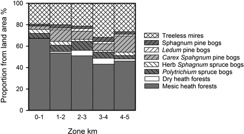
Fig. 2. Proportions of different vegetation types from the total land area in different distance zones from the village centres.
3.2 Effect of villages on forest age along the 5 km distance gradient
The effect of villages on the age of forests was the clearest in mesic heath forest stands (Fig. 3A); when the forest age of the nearest zone (0–0.5 km) was compared to that of the most distant zone (4–5 km) there was 2.2 fold increase in estimated marginal means. In Polytrichium spruce bog stands the age of forests increased also as the distance from villages increased, but this increase was not as strong as in the case of mesic heath forest stands (Fig. 3B); there was 1.5 fold increase in estimated marginal means between the nearest and the most distant zones. In the Carex-Sphagnum pine bog stands (Fig. 3C) the effect of villages was also significant and the increase of the estimated marginal means of forest age was approximately of the same level (1.7 fold increase) as that in the case of Polytrichium spruce bog type stands. The results of Generalized Linear Mixed Model analyses are presented in Table 1.
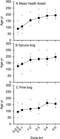
Fig. 3. Estimated marginal means of forest age in different distance zones of three dominant forest types; A) Mesic heath forests of Vaccinium type, B) Spruce bogs of Polytrichium type and C) Pine bogs of Carex Sphagnum type (solid circles). The village specific values (grey crosses) show the variation in the data. Results of GLMM are presented in Table 1.
| Table 1. Results of generalized linear mixed model analyses testing the effect of distance zone on the age of forests around the villages for the three most abundant growth site types and on the volume of growing stock, proportion of birch and proportion of spruce in mesic heath forests. | |||
| Landscape property | df | F | P |
| Age of mesic heath forests | 5,30 | 25.728 | < 0.001 |
| Age of Polytrichium spruce bogs | 5,22 | 2.697 | 0.048 |
| Age of Carex Sphagnum pine bogs | 5,24 | 3.080 | 0.028 |
| Volume of standing stock in mesic heath forests | 5,30 | 3.856 | 0.008 |
| Proportion of birch in mesic heath forests | 5,30 | 14.348 | < 0.001 |
| Proportion of spruce in mesic heath forests | 5,30 | 5.628 | 0.001 |
3.3 Effect of villages on volume and proportions of tree species on mesic heath forest stands along the 5 km distance gradient
Distance from villages affected volume and tree species composition of the mesic heath forest stands. The volume of living standing stock increased from 165 m3 ha–1 in the closest distance zone (0–0.5 km) to approximately 200 m3 ha–1 in the 5 km perimeter, based on estimated marginal means of the model (Table 1, Fig. 4A). The proportion of birch in the standing stock dropped from 37% to 7% within the distance of 3 km from the forest edge and remained at the low level (< 5%) after this (Fig. 4B). At the same time the proportion of spruce in the standing stock increased from 26% to 58% within the distance of 2 km, starting from the forest edge, and remained at the level of > 50% after that point to the perimeter (Fig. 4C). The results of Generalized Linear Mixed Models are presented in Table 1.
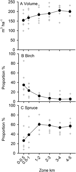
Fig. 4. Estimated marginal means of A) volume of stems, B) proportion of birch and C) proportion of spruce in mesic heath forests of different distance zones (solid circles). The village specific values (grey crosses) show the variation in the data. Results of GLMM are presented in Table 1.
3.4 Size of villages
There were marked differences in the population size and number of houses of the six studied villages and, as expected, there was significant negative correlation between them and the average age of the surrounding forests (P < 0.05, values of rs are shown in the Table 2). The total size of population in 1905 in the area of northern part of the NP was 1659 people living in 248 households. The area of the northern part was 3443 km2, hence the population density was 0.48 inhabitants per km2. The area of usable land (water and treeless mires excluded) was 1313 km2 and the population density was 1.26 inhabitants per km2 of usable land.
| Table 2. The size of human population, number of households and average age of forests surrounding the villages, according to the 1905 census (Blagoveshchenski 1907; Golubtsov 1907). Age of forests (Myrtillus-type only) is based on estimated marginal means of the GLM analysis (see Table 1). Results of one tailed non-parametric correlation test are given in the last line. | ||||
| Village | Houses | Population | Age of forest | |
| 1 | Kalgazhiga | 94 | 671 | 127 |
| 2 | Korkala | 22 | 212 | 140 |
| 3 | Luza | 42 | 249 | 142 |
| 4 | Kalakunda | 10 | 70 | 211 |
| 5 | Zagorie | 23 | 128 | 129 |
| 6 | Gumarnavolok | 16 | 115 | 160 |
| rs Age vs. | –0.829* | –0.771* | ||
| * Indicates significance of correlation at level of P < 0.05 (1-tailed) | ||||
3.5 Forest age, stand volume and proportions of tree species in the larger landscape
The distance from former villages significantly affected the stand age and proportion of spruce on the mesic heath forest stands, as well as in the scale of the whole landscape (linear regression, P < 0.001). The nonlinear regression equations fitted in the data slightly better than the linear ones both in the case of stand age and proportion of spruce. The shape of the nonlinear curve (Fig. 5A) shows that the effect of villages on the stand age was the strongest within the distance of 5 km. After this the regression curve seems to achieve an asymptote. The sigmoid model fitted the best in the data showing the relationship between distance and the proportion of spruce. Here there seems to be a sudden increase in the proportion of spruce between 15 and 20 km (Fig. 5B). The effect of villages on the stand age and proportion of spruce also can be clearly seen in the maps drawn from the results of spatial interpolation (Fig. 6). In the case of stand volume and proportion of birch, no relationship was found (P > 0.05). The results of regression analyses are shown in Table 3.
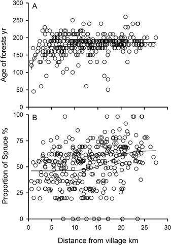
Fig. 5. Nonlinear regression curves for A) stand age and B) proportion of spruce from the standing stock in mesic heath forest in relationship to the distance from the nearest village in the northern part of the Vodlozero NP. The equations of curves and the results of regression analyses are shown in Table 4.
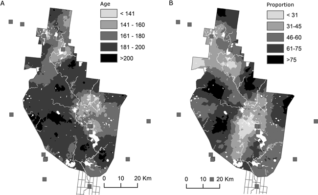
Fig. 6. The maps showing A) age and B) proportion of spruce in mesic heath forests of the northern part of the Vodlozero NP. The results are based on spatial interpolation (see Methods for details). The locations of old villages are shown with gray squares. Rivers and lakes are shown with white color.
| Table 3. Relationship of distance from the nearest village and stand parameters in the whole northern part of the Vodlozero NP (results of the regression analyses). Proportion of birch was not analyzed due to strong skewness of the data distribution even after arcsin-square root transformation. | |||||
| Distance vs. | Linear | Nonlinear | |||
| P | r2 | Equation | P | r2 | |
| Age | < 0.0001 | 0.052 | < 0.0001 | 0.099 | |
| Volume | 0.0832 | - | - | - | - |
| Proportion of spruce | < 0.0001 | 0.099 | 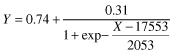 | < 0.0001 | 0.115 |
4 Discussion
The analysis of forest inventory data showed that the influence of past human populations on the forest structure was evident in the populated parts of the Vodlozero National Park 38 years after the abandonment of the villages. We were able to easily distinguish the effects of villages on tree species composition, age and volume of the stands within the range of 0to 2 km from the edges of former fields of villages. These changes in the forest landscapes surrounding the villages resulted from the intensive use of wood for different commodities needed for households and farming, in addition to short rotation slash and burn agriculture. These “short range” effects are well known and were easy to predict in advance (Chernyakova 2014; Tikkanen et al. 2014). We will discuss the details later in this paper.
4.1 Large scale patterns in the landscape
In contrast to the “short range” effects, the detection of “long range” effects of villages on the tree species composition in the landscape of the whole northern part of the NP was more surprising. By the long range effects we mean the change in abundance of spruce in mesic mineral soil stands in relationship to the distance from the villages (Figs. 5B and 6B). Actually, the increase in the abundance of spruce along the distance from the villages was linked to the decrease in the abundance of pine, because these were the two dominant forest tree species growing in mesic heath forests. This pattern can hardly be explained by climatic or geomorphologic factors. In the results, there are not any north-south or east-west trends, and the topography of landscape is relatively flat, except in the very northernmost part of the NP. Therefore, the human impact is the most plausible factor behind this pattern.
Boreal forests were actively used for slash and burn agriculture for centuries in eastern Fennoscandia (Heikinheimo 1915; Taavitsainen et al. 1998; Orrman 2003; Chernyakova 2014b) which could led to the increased fire frequency in the forest landscape (Zackrisson 1977; Lehtonen et al. 1996; Lehtonen and Kolström 2000; Pitkänen et al. 2002; Wallenius et al. 2005). In addition to slash and burn agriculture, the other modes of human activity can increase the frequency of unintended fires in the forests near the villages. These include, for example, camp-fires made during hunting, fishing, hay making and berry picking trips. In old times, these kinds of activities were a common and essential part of the people’s livelihood in the villages of forested periphery of the boreal NW Europe.
Spruce, out of all the local forest tree species, has the thinnest bark and therefore it is non-resistant to forest fires, unlike old pines which have a very thick bark and can resist fires well. It is not rare to see old pines with multiple fire scars in those sites of Fennoscandia which are still largely unaffected by industrial forestry (eg. Lehtonen and Kolström 2000). In addition, pine is able to re-colonize burned areas more rapidly than spruce. Huttunen (1980) showed, that starting from the 11th century, the increased amount of charcoal and pollen of crop plants occured together with the decline of spruce pollen in lake sediments, in Lammi (Southern Finland). At the same time, the amount of pine pollen started to decline only from the mid-18th century; after this time point the mean interval between successive fires, indicated by charcoal layers in the sediment, shortened from 56 years to 26 years (Huttunen 1980). If we agree that the occurrence of forest fires has been more frequent closer to villages than in more remote areas, it can well explain the observed pattern in the abundance of spruce in the larger landscape (Fig. 6B).
On the other hand, from the historic sources we know that the use of forests for slash and burn agriculture was prohibited by law in Russia already in 1876 (Chernyakova 2014), and the rural economy based on it collapsed totally after the Soviet Revolution. Therefore, it is somewhat unexpected to find out that this past human activity would still have such a clear and strong effect on the structure of forest landscape in the boreal NW Europe today.
Loggings have probably had a strong local effect on the current forest structure. According to Gromtsev (2001), water ways have been an important system for timber transportation, and there have been selective loggings of high quality pine logs along the shores of the River Ileksa at the end of 19th century. For example, the selective loggings may explain the spot of younger forests in the central area of the Fig. 6A, where there is a dense river network. However, this does not undermine our conclusion about the profound effect of locations of villages and fire frequency on larger forest landscapes. If the past, selective loggings would be the dominant factor dictating the landscape structure, we should find an opposite pattern (compared to that in Fig. 6B) or no pattern at all between the tree species proportions and distance from village, because pine was the preferred timber tree.
Because we are able to find a significant effect of past human activity in very sparsely populated areas (less than 2 inhabitants per km2 in Vodlozero), we can assume that the effect of fires on tree species composition of forests has been even more dramatic in the areas that have been densely populated. For example, in the province of Savo (south boreal Finland), the average population density was 4.6 inhabitants per km2 of productive land already at the beginning of the 19th century, and the population density raised to 12.1 inhabitants per km2 of productive land in 1910 (Wirilander 1960, 2008; Anon. 2011). Heikinheimo (1915) calculated that in the province of Savo, from 56.6 up to 82.1 percent of mineral soil forests were used for slash and burn in the late 18th and early 19th centuries. These figures strongly support the view that traditional agriculture in preindustrial northern periphery of Europe may have had a profound effect on forest landscape.
4.2 Forest landscape around the villages
The short range effects of villages were apparent on all three analyzed stand types, not only on soils suitable for slash and burn agriculture. A similar strong effect of villages on forest age up to 1–2 km from the village edges was also found in recent field inventories made in western White Sea Karelia (Tikkanen et al. 2014). Together these findings suggest that forest clearances around the villages were typical in early 20th century Karelia. The landscape pattern with clearly decreasing human impact in function of distance from villages was probably also common in other parts of boreal Europe at the end of the 19th century (Heikinheimo 1915; Huttunen 1980). However, other patterns of forest landscapes and distribution of human populations also may have existed. In the remote forested areas of Eastern Finland, the forests were littered by solitary farmsteads instead of compact villages (Aarnio 1999). This may have resulted in more widespread but fine-grained land use (in terms of marks of human disturbance in the landscape) in Eastern Finland compared to Karelia.
Wood was used for many purposes up to 1950’s in rural areas of Northern Europe. Among all possible commodities, the use of wood for heating during long and cold winter period was the most important one (Soininen 1974; Myllyntaus and Mattila 2001; Lindmark and Andersson 2010). Wood was also used as material for all kind of buildings, fences, goods and utensils needed for households and farms, until the manufactured products replaced them in the 20th century. Moreover, short rotation slash and burning was practiced near villages, and browsing by livestock kept the surrounding landscape open, as can be seen in contemporary photographs.
5 Concluding remarks
Most importantly, this study demonstrates that the recovery of boreal forests after severe or frequent damage is a very slow process. A century after the end of slash and burn agriculture and after 40 years of the abandonment of villages, the signs of past human activity is still visible in the landscape. This gives us some perspective to evaluate the effects of modern industrial forestry which is based on total clear cuts with 80 to 100 yr rotation cycles and subsequent soil scarification. Currently, we still know only a little about the recovery process of boreal forest ecosystems after the clear cuts in higher level of ecosystem processes (Reiss et al. 2009), but now we can estimate that centuries are needed for the total recovery at the landscape level (see also Lilja et al. 2006). In order to improve our knowledge about the recovery of ecosystem processes at the landscape level, the Vodlozero NP and adjacent commercial forests may provide a natural landscape level laboratory of its own class to study resilience of boreal forest ecosystems under variable disturbance regimes within the same geographical area.
Acknowledgements
We wish to thank the Vodlozero NP and V.Y. Dedov for fruitful co-operation and letting us to use the forest data. We are grateful to O.V. Chernyakov for his help with software problems. Y.M. Kilin helped us with contacts in the Vodlozero NP and O.L. Kuznetsov – with the names of mire vegetation types. We also thank H. Simola and two anonymous referees for constructive commenting the manuscript. A. Ananina is thanked for correcting English language. The work of OPT in Petrozavodsk was supported by the Academy of Finland (grant No. 258447/2012) and work of IC by the state order of the Ministry of Education and Science of the Russian Federation, GBT № 653-14.
References
Aarnio J. (1999). Kaskiviljelystä metsätöihin: tutkimus Pielisjärven Kruununmetsistä ja kruununmetsätorppareista vuoteen 1910. Department of Geography, University of Joensuu, Doctoral dissertation 4. 190 p. + app.
Ahti T., Hämet-Ahti L., Jalas J. (1968). Vegetation zones and their sections in northwestern Europe. Annales Botanici Fennici 5: 169–211.
Bellemare J., Motzkin G., Foster D.R. (2002). Legacies of the agriculural past in the forested present: an assessment of historical land-use effects on rich mesic forests. Journal of Biogeography 29: 1401–1420. http://dx.doi.org/10.1046/j.1365-2699.2002.00762.x.
Berglund H., Jonsson B.G. (2005). Verifying an extinction debt among lichens and fungi in northern Swedish boreal forests. Conservation Biology 19: 339–348. http://dx.doi.org/10.1111/j.1523-1739.2005.00550.x.
Blagoveshchenski I.I. (1907). Список населенных мест Олонецкой губернии по сведениям за 1905 год / Олонецкий Губернский Статистический Комитет; Сост. И. И. Благовещенский. Петрозаводск: Олонецкая губернская типография.
Burnett C., Fall A., Tomppo E., Kalliola R. (2003). Monitoring current status of and trends in boreal forest land use in Russian Karelia. Conservation Ecology 7: 8. http://www.ecologyandsociety.org/vol7/iss2/art8/print.pdf. [Cited December 2013].
Ericsson T.S., Berglund H., Östlund L. (2005). History and forest biodiversity of woodland key habitats in south boreal Sweden. Biological Conservation 122: 289–303. http://dx.doi.org/10.1016/j.biocon.2004.07.019.
Fridman J.,Walheim M. (2000). Amount, structure, and dynamics of dead wood on managed forestland in Sweden. Forest Ecology and Management 131: 23–36. http://dx.doi.org/10.1016/S0378-1127(99)00208-X.
Fritschle J.A. (2012). Identification of old-growth forest reference ecosystems using historic land surveys, Redwood National Park, California. Restoration Ecology 20: 679–687. http://dx.doi.org/10.1111/j.1526-100X.2011.00832.x.
Chernyakova I. (2013a). Водлозерье — поселенческие ландшафты и социальный потенциал в свете историко-географических данных конца XVIII века. Carelica 1(10): 19–39. http://carelica.petrsu.ru/2013/Chernyakova_1.pdf. [Cited December 2013].
Chernyakova I. (2013b). Карельские волости и их обитатели как объект добрых намерений имперского правительства в XIX веке. Carelica 1(10): 70–81. http://carelica.petrsu.ru/2013/Chernyakova_2.pdf. [Cited December 2013].
Chernyakova I. (2014). Was the governmental prohibition of slash-and-burn a reasonable solution for Russian Karelia in the nineteenth century as observed by educated contemporaries? Finnish Environment. [Accepted].
Gerhard F., Foster D.R. (2002). Physiographical and historical effects on forest vegetation in central New England, USA. Journal of Biogeography 29: 1421–1437. http://dx.doi.org/10.1046/j.1365-2699.2002.00763.x.
Golubtsov N.A. (1907). Список населенных мест Архангельской губернии к 1905 году / Архангельский Губернский Статистический Комитет; сост. Н. А. Голубцов. Архангельск: Губернская типография.
Gu W., Heikkilä R., Hanski I. (2002). Estimating the consequences of habitat fragmentation on extinction risk in dynamic landscapes. Landscape Ecology 17: 699–710. http://dx.doi.org/10.1023/A:1022993317717.
Gromtsev A.N. (2001). Сравнительный анализ таежного ландшафта на разных стадиях антропогенной трансформации (на примере карельской части национального парка «Водлозерский» и сопредельной территории). In: Национальный парк «Водлозерский»: природное разнообразие и культурное наследие. Петрозаводск. С. 102–110.
Gromtsev A.N. (2003). Landscape models of the primeval forests. In: Gromtsev A.N., Kitaev S.P., Krutov V.I., Kuznetsov O.L., Lindholm T., Yakolev E.B. (eds.). Biotic diversity of Karelia: conditions for formation, communities and species. Karelian Research Centre of RAS, Petrozavodsk. p. 47–50.
Heikinheimo O. (1915). Kaskiviljelyksen vaikutus Suomen metsiin. Doctoral dissertation.Filosofinen tiedekunta, Keisarillinen Aleksanterin yliopisto, Helsinki. 264 p. + app.
Huttunen P. (1980). Early land use, especially the slash-and-burn cultivation in the commune of Lammi, southern Finland, interpreted mainly using pollen and charcoal analyses. Acta Botanica Fennica 113: 1–45.
Ihalainen A., Mäkelä H. (2009). Kuolleen puuston määrä Etelä- ja Pohjois-Suomessa 2004–2007. Metsätieteen aikakauskirja 1/2009: 35–56.
Jönsson M.T., Jonsson B.G. (2007). Assessing coarse woody debris in Swedish woodland key habitats: Implications for conservation and management. Forest Ecology and Management 242: 363–373. http://dx.doi.org/10.1016/j.foreco.2007.01.054.
Josefsson T., Gunnarson B., Liedgren L., Bergman I., Östlund L. (2010). Historical human influence on forest composition and structure in boreal Fennoscandia. Canadian Journal of Forest Research 40: 872–884. http://dx.doi.org/10.1139/X10-033.
Kobyakov K., Jakolev J. (eds.). (2013). Atlas of high conservation value areas, and analysis of gaps and representativeness of the protected area network in northwest Russia. Finnish Environment Institute.
Lehtonen H., Huttunen P. (1997). History of forest fires in eastern Finland from the 15th century AD – the possible effects of slash and burn cultivation. Holocene 7: 223–228. http://dx.doi.org/10.1177/095968369700700210.
Lehtonen H., Kolström T. (2000). Forest fire history in Viena Karelia. Scandinavian Journal of Forest Research 15: 585–590. http://dx.doi.org/10.1080/02827580050216833.
Lehtonen H., Huttunen P., Zetterberg P. (1996). Influence of man on forest fire frequency in North Karelia, Finland, as evidenced by fire scars on Scots pines. Annales Botanici Fennici 33: 257–263.
Lihtonen V. (1949). Piirteitä valtion metsätaloudesta. Silva Fennica 66: 1–46. http://dx.doi.org/10.14214/sf.a9088.
Lilja S., Kuuluvainen T. (2005). Structure of old Pinus sylvestris dominated forest stands along a geographic and human impact gradient in mid-boreal Fennoscandia. Silva Fennica 39: 407–428. http://dx.doi.org/10.14214/sf.377.
Lilja S., Wallenius T., Kuuluvainen T. (2006) Structure and development of old Picea abies forests in northern boreal Fennoscandia. Ecoscience 13: 181–192. http://dx.doi.org/10.2980/i1195-6860-13-2-181.1.
Lindbladh M., Niklasson M., Nilsson S.G. (2003). Long-time record of fire and open canopy in a high biodiversity forest in southeast Sweden. Biological Conservation 114: 231–243. http://dx.doi.org/10.1016/S0006-3207(03)00043-0.
Linder P., Östlund L. (1998). Structural changes in three mid-boreal Swedish forest landscapes, 1885–1996. Biological Conservation 85: 9–19. http://dx.doi.org/10.1016/S0006-3207(97)00168-7.
Lindmark M., Anderson L.F. (2010). Household firewood consumption in Sweden during the nineteenth century. Journal of Northern Studies 2: 55–78.
Loginov K.K. (2010). Историческая справка о поселениях Водлозерья. In: Водлозерский национальный парк. http://www.vodlozero.ru/nauka/tradic/Vodlozero-village-history-ethnography.html. [Cited November 2013].
Lõhmus A., Lõhmus P. (2008). First-generation forests are not necessarily worse than long-term managed forests for lichens and bryophytes. Restoration Ecology 16: 231–239. http://dx.doi.org/10.1111/j.1526-100X.2007.00266.x.
Lukashov A.D. (2003). Geomorphological characteristics. In: Gromtsev A.N., Kitaev S.P., Krutov V.I., Kuznetsov O.L., Lindholm T., Yakolev E.B. (eds.). Biotic diversity of Karelia: conditions for formation, communities and species. Karelian Research Centre of RAS, Petrozavodsk. p. 12–17.
Mäkelä H., Pekkarinen A. (2004). Estimation of forest stand volumes by Landsat TM imagery and stand-level field inventory data. Forest Ecology and Management 196: 245–255. http://dx.doi.org/10.1016/j.foreco.2004.02.049.
Ministry of Natural Resources (2008). Лесоустроителная инстукция. Прикас Минприроды Россиа от 06.02.2008 № 31.
Mithen S. (2003). After the ice: a global human history, 20,000–5000 BC. Weidenfeld and Nicolson, London.
Muukkonen P., Heiskanen J. (2005). Estimating biomass for boreal forests using ASTER satellite data combined with standwise forest inventory data. Remote Sensing of Environment 99: 434–447. http://dx.doi.org/10.1016/j.rse.2005.09.011.
Myllyntaus T., Mattila T. (2002). Decline or increase? The standing timber stock in Finland, 1800–1997. Ecological Economy 41: 271–288. http://dx.doi.org/10.1016/S0921-8009(02)00034-4.
Orrman E. (2003). Itäinen kaskikulttuuri. In: Rasila V., Jutikkala E., Mäkelä-Alitalo A. (eds.). Suomen maatalouden historia 1: perinteisen maatalouden aika – esihistoriasta 1870-luvulle. Suomalaisen Kirjallisuuden Seura, Helsinki. p. 98–103.
Östlund L., Zackrisson O., Axelsson A.L. (1997). The history and transformation of a Scandinavian boreal forest landscape since the 19th century. Canadian Journal of Forest Research 27: 1198–1206. http://dx.doi.org/10.1139/x97-070.
Parpola A., Åberg V. (2009). Metsävaltio. Metsähallitus ja Suomi 1859–2009. Edita/Metsähallitus, Helsinki.
Parshall T., Foster D.R. (2002). Fire on the New England landscape: regional and temporal variation, cultural and environmental controls. Journal of Biogeography 29: 1305–1317. http://dx.doi.org/10.1046/j.1365-2699.2002.00758.x.
Pennanen J., Kuuluvainen T. (2002). A spatial simulation approach to natural forest landscape dynamics in boreal Fennoscandia. Forest Ecology and Management 164: 157–175. http://dx.doi.org/10.1016/S0378-1127(01)00608-9.
Pitkänen A., Huttunen P., Jugner H., Tolonen K. (2002). A 10 000 year local forest fire history in a dry heath forest site in eastern Finland, reconstructed from charcoal layer records of a small mire. Canadian Journal of Forest Research 32: 1875–1880. http://dx.doi.org/10.1139/x02-103.
Reiss J., Bridle J.R., Montoya J.M., Woodward G. (2009). Emerging horizons in biodiversity and ecosystem functioning research. TREE 24: 505–514. http://dx.doi.org/10.1016/j.tree.2009.03.018.
Rouvinen S., Kouki J. (2002). Spatiotemporal availability of dead wood in protected old-growth forests: a case study from boreal forests in eastern Finland. Scandinavian Journal of Forest Research 17: 317–329. http://dx.doi.org/10.1080/02827580260138071.
Rouvinen S., Kuuluvainen T. (2001). Amount and spatial distribution of standing and downed dead trees in two areas of different fire history in a boreal Scots pine forest. Ecological Bulletins 49: 115–127.
Rouvinen S., Kuuluvainen T., Siitonen J. (2002). Tree mortality in a Pinus sylvestris dominated boreal forest landscape in Vienansalo wilderness, eastern Fennoscandia. Silva Fennica 36: 127–145. http://dx.doi.org/10.14214/sf.554.
Rytteri T. (2006). Metsän haltija: metsähallituksen yhteiskunnallinen vastuu vuosina 1859–2005. Bidrag till kännedoms av Finlands natur och folk 167. 180 p.
Soininen A.M. (1974). Vanha maataloutemme. Maatalous ja maatalousväestö Suomessa perinnäisen maatalouden loppukaudella 1720-luvulta 1870-luvulle. Maataloustieteellinen Aikakausikirja 46 (suppl.). 459 p.
Stokland J.N. (2001). The coarse woody debris profile: an archive of recent forest history and an important biodiversity indicator. Ecological Bulletins 49: 71–83.
Syrjänen K., Kalliola R., Puolasmaa A., Mattsson J. (1994). Landscape structure and forest dynamics in subcontinental Russian European taiga. Annales Zoologici Fennici 31:19–34.
Taavitsainen J.-P., Simola H., Grönlund E. (1998). Cultivation history beyond the periphery: early agriculture in the North European boreal forest. Journal of World Prehistory 12: 199–253. http://dx.doi.org/10.1023/A:1022398001684.
Tikkanen O.-P., Punttila P., Heikkilä R. (2009). Species-area relationships of red-listed species in old boreal forests: a large scale data analysis. Diversity and Distributions 15: 852–862. http://dx.doi.org/10.1111/j.1472-4642.2009.00590.x.
Tikkanen O.-P., Ruokolainen A., Heikkilä R. (2014). Recovery of boreal forest near abandoned villages in western White Sea Karelia, Russia. Scandinavian Journal of Forest Research 29: 152–161. http://dx.doi.org/10.1080/02827581.2014.881543.
Trofimov A.N. (1989). Атлас Карельской АССР. Главное управление геодезии и картографии при Совете Министров СССР.
Wallenius T.H., Pitkänen A., Kuuluvainen T., Pennanen J., Karttunen H. (2005). Fire history and forest age distribution of an unmanaged Picea abies dominated landscape. Canadian Journal of Forest Research 35: 1540–1552. http://dx.doi.org/10.1139/x05-050.
Williams M. (2003). Deforesting the Earth: from prehistory to global crisis. The University of Chicago Press.
Wirilander H. (2008). Savon historia IV: Uudistuksiin heräävä Savo 1870–1918. Savon säätiö, Kuopio.
Wirilander K. (1960). Savon historia III: Savo kaskisavujen kautena 1721–1870. Savon säätiö, Kuopio.
Zackrisson O. (1977). The influence of forest fires in the north Swedish boreal forest. Oikos 29: 22–32. http://dx.doi.org/10.2307/3543289.
Total of 63 references
