Chunyu Zhu,
Jiaojun Zhu  ,
Xiao Zheng,
Deliang Lu,
Xiufen Li
,
Xiao Zheng,
Deliang Lu,
Xiufen Li
Comparison of gap formation and distribution pattern induced by wind/snowstorm and flood in a temperate secondary forest ecosystem, Northeast China
Zhu C., Zhu J., Zheng X., Lu D., Li X. (2017). Comparison of gap formation and distribution pattern induced by wind/snowstorm and flood in a temperate secondary forest ecosystem, Northeast China. Silva Fennica vol. 51 no. 5 article id 7693. https://doi.org/10.14214/sf.7693
Highlights
- The canopy gaps induced by wind/snowstorm were aggregated in steep slope and high altitude areas, while the gaps formed by flood were gathered in steep slope and low altitude areas
- The wind/snowstorm mainly driven the formation of medium gaps, while the flood mainly promoted the percentage of small gaps and vacant lands.
Abstract
Canopy gap is the driving force of forest succession. Due to the uncontrollability, however, the influences of natural disturbances on gap formation and gap distribution pattern have been rarely understood in temperate secondary forest ecosystems. We monitored the gap formation and gap distribution pattern using high-resolution remote sensing images before and after two disturbances (wind/snowstorm in 2003 and flood in 2013). The results showed that after wind/snowstorm, the gap nearest neighbor index (GNNI) decreased, the vacant land area did not obviously change while the gap fraction and gaps density (especially medium size) increased. After the flood, GNNI decreased, the number of small gaps increased but larger gaps were in many cases extended to vacant land areas leading to a smaller total number of medium and large gaps but considerable increase in vacant land area. We also found that the gap densities increased with slope and altitude for wind/snowstorm-formed gaps, but they increased with increasing slope and decreasing altitude for flood-formed gaps. These results indicated that gaps were aggregated in steep slope and high altitude areas after wind/snowstorm, but in steep slope and low altitude areas after the flood. Medium gaps were mainly created by the wind/snowstorm due to the individual-level death of dominant tree with the continuous fall of surrounding trees. While, vacant lands were obviously created during the flood because of integral sweeping. Besides, smaller trees were easily damaged by runoff of flood, which induced small gaps. In summary, forest managers may pay more attention to use gaps to accelerate forest succession after wind/snowstorms and to restore vegetation in vacant lands after floods.
Keywords
secondary forests;
canopy opening;
windstorm;
flood;
large scale
- Zhu, E-mail Chunyuzhu123@126.com
-
Zhu,
E-mail
jiaojunzhu@iae.ac.cn
- Zheng, E-mail xiaozheng@iae.ac.cn
- Lu, E-mail delianglu14@hotmail.com
- Li, E-mail delianglu14@hotmail.com
Received 5 April 2017 Accepted 6 October 2017 Published 26 October 2017
Views 123639
Available at https://doi.org/10.14214/sf.7693 | Download PDF

1 Introduction
Canopy gaps, as one of the common disturbances in forests, are among the driving forces of forest cycle (Watt 1947; Whitmore 1989; Zhu et al. 2015). Gaps provide more opportunities for trees with different ecological recruitment patterns by increasing light availability and spatial heterogeneity (McCarthy 2001; Richards and Hart 2011; Lu et al. 2015). The impact of gap regimes on plant population dynamics is of interest to both foresters and ecologists. Spatial patterns of gaps include attributes such as gap fraction, size, shape, and spatial distribution, have particular ecological effects on regeneration and succession of forests (Peterson et al. 2013). Gap fraction and density can reflect the intensity of the disturbances (Veblen and Lara 1992; Vogt et al. 2013), which potentially influence the seed germination and seedling emergence of the light-demanding species within the gaps. Gap size, creating diverse habitats, strongly influences environmental factors and seed dispersal, germination, seedling emergence, and establishment (Turner and Tinker 2003). Gap shapes, such as dumb-bell, circular, ellipse, and triangle, substantially influence gap microclimates and can reflect the direction and the architecture of the falling tree (Brown 1993; Salvador-Van Eysenrode et al. 1998). The effects of gap edge on the within-gap conditions increase the irregularity of gap shape because of the increased resources competition (Gagnon et al. 2004). The gap spatial distributions directly determine the light regimes temporally and spatially, driving recruitment to the upper layers of the stand, thereby resulting in an uneven-aged forests. (Marthews et al. 2008). Hence, it has been suggested that quantifying gap characteristics is essential for understanding disturbance and regeneration dynamics and the consequent impacts on ecological processes of forest ecosystems (Gagnon et al. 2004).
The drivers of natural gap formation include lightning, diseases, windstorm, snowfall, insect outbreaks, drought, flood and fires (Muscolo et al. 2014). Numerous studies in both temperate and tropical forests show that there is considerable heterogeneity in gap pattern induced by different disturbances. Vogt et al. (2013) detected that lightning disturbances created gaps by randomly causing the death of small tree groups, and partly promoted the conversion of plantation forests into near-natural forests. Diseases, such as the beech bark disease in North America, were common to find in the poorly-drained soils, causing gradual widening of gaps over time (Krasny and Whitmore 1992). Insect outbreaks, such as the spruce budworm (Choristoneura fumiferana (Clem.)), could create gaps that were often ideal locations for shade-intolerant, non-host species (Bouchard et al. 2006). Windstorms, as one of the most important natural disturbances, play a critical role on timber production and ecological services in temperate forests (Martinezramos et al. 1989; Young and Hubbell 1991). It has been demonstrated that gap size increased with the magnitude of windstorms. However, most studies conducted in temperate forests focus on the catastrophic windstorms, such as tornadoes and hurricanes (Clinton and Baker 2000; Kramer et al. 2014; Cannon et al. 2016), few attentions were paid to the intermediate windstorm, such as the wind/snowstorm, which may cause individual tree-level death (Nagel and Diaci 2006). Floods, as another important large-scale natural disturbance, can significantly change the canopy openness and litter microhabitats in forests (Myster 2007). Floods may break trunks, uproot trees and even trigger landslides due to the impact of running water or weight of debris (Balslev et al. 1987). Researchers usually regarded gaps as small-scale disturbances and made comparisons with flood disturbance in changing forest species distributions, plant community diversity and physical structure (Myster 2010; Boyd et al. 2013). However, the driving effects of flood on gap formation were often neglected.
Secondary forests as the major forest resources worldwide have been paid great attentions recently (Zhu et al. 2007). Especially in Northeast China, secondary forests taking more than 70% of the forest resource components of this region (ca. 1/3 of China national forest areas) play a more important role in conservation of ecological environments and providing forest products. Because of anthropological disturbances such as cutting, collecting, lopping, clearing for cultivation and overgrazing, these secondary forests are experiencing obvious vegetation degradation (Zhu et al. 2007). To minimize these threats, most of the secondary forests have been transformed to non-commercial forest ecosystems with the implementation of the Natural Forest Protection Project (Li et al. 2004; Zhu et al. 2006). Natural disturbances, particularly those with large scales, have become the principal driving forces of gap formation. Therefore, it is essential to carry out the study of large-scale disturbances driving gap formation and distribution pattern for the secondary forests in Northeast China. The secondary forest ecosystems (defined as the mosaics of natural secondary forests and artificial plantation forests) in montane regions of eastern Liaoning Province, Northeast China suffered wind/snowstorm in the early spring of 2003 and flood in the summer of 2013. It provided us an opportunity to study the influence of two kinds of large-scale natural disturbances on gap formation and distribution pattern. Traditional methods based on field survey are limited in detecting gaps over a large area and identifying the spatial distribution of gaps (Vepakomma et al. 2008). However, multispectral satellite images were used to research canopy gaps at landscape scale and show more spatial distribution details in forest canopy (Potter 2014).
In the present study, we derived gap data from four remote sensing images 1) to quantify the change of gap pattern before and after the wind/snowstorm and flood in the secondary forest ecosystems at a landscape scale, and 2) to compare the wind/snowstorm and flood disturbances in driving gap formation and distribution pattern. We hypothesize that the gaps induced by flood may be larger than those induced by wind/snowstorm in size, because the flood in montane areas can create more extended disturbed areas, particularly, when the landslides occurred (Frolking et al. 2009) We hope our findings may provide knowledge for managing the forest after different disturbances.
2 Materials and methods
2.1 Study area
The study was carried out in Qingyuan Forest CERN (Chinese Ecosystem Research Network), Chinese Academy of Sciences (CAS), a mountain region in eastern Liaoning Province, Northeast China (41°51´N, 124°55´E) (Fig. 1). It is continental monsoon climate with a hot rainy summer and a cold dry winter. The annual precipitation is 700–850 mm, 80% of which falls between June and August. The mean annual temperature is 4.7 °C, with an annual minimum of –37.6 °C and an annual maximum of 36.5 °C. The frost-free period is 130 days. The soil type is a typical brown soil, and the parent rock is composed of granite and granite-gneiss. The majority of the plots are on a plateau at an elevation of 550–1116 m above sea level (Zhu et al. 2007).
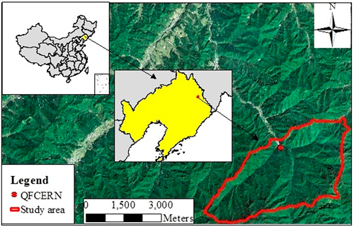
Fig. 1. The location of the study area (QFCERN: Qingyuan forest CERN).
The secondary forest ecosystem had been dominated by old-growth mixed broadleaved-Korean pine (Pinus koraiensis Siebold & Zucc.) forests until the 1930s. After decades of timber harvest and massive controlled burns disturbances, the old-growth mixed broadleaved-Korean pine forests had been replaced by the secondary forests (Yan et al. 2012). During 1960s, some of the secondary forests were replaced by larch plantations to meet the timber demand (Yang et al. 2012). The coexistence of secondary forests and larch plantations gradually formed a typical temperate secondary forest ecosystem in Northeast China. The current dominant tree species include Fraxinus rhynchophylla Hance, Juglans mandshurica Maxim., Phellodendron amurense Rupr., Quercus mongolica Fisch. ex Ledeb., Populus davidiana Dode and Acer mono Maxim. (Yan et al. 2010).
2.2 Conditions of the wind/snowstorm and the flood
The wind/snowstorm occurred in March 2003. According to the local meteorological data, the precipitation of snowfall reached 10.5 mm in 12 hours, which was far beyond the snowstorm standard of 10 mm in 24 h (National Meteorological Criteria of China). The temperature ranged from –6.6 °C to –1.4 °C in 24 h during the snowfall, and the ground temperature was close to 0 °C. Under these temperature conditions, the snowfall was sticky and heavy. Wind gust speeds exceeding 10 m s–1 were observed every day after the heavy snow between 29 March and 4 April 2003 (Zhu et al. 2006). In August 2013, a flood occurred after a heavy rainstorm (330 mm within eight hours), and caused widespread flood and landslides. In contrast to the 700–850 mm of annual precipitation, this rainstorm was characterized by high intensity and large quantity.
2.3 Image interpretation
We selected four periods of remote sensing images before and after the two disturbances (2002 and 2003 for wind/snowstorm; 2011 and 2014 for flood) to derive the gap characteristics. The four images were cloud-free images of the whole study area. First, all images were initially processed from digital number values to surface reflectance using the nominal values of Gain and Offset, and applied atmospheric correction using dark subtraction algorithm (Garbarino et al. 2012). Then, 20–30 uniformly distributed ground control points derived from a 1:5000 topographic map of the study area were used for geo-referencing and ortho-rectifing all images. The root-mean-square error (RMSE) among all images was less than one pixel. Furthermore, to improve the spatial resolution of images, we merged the multispectral images with corresponding panchromatic images by wavelet transform. The spatial resolution of all images for gap classification was unified to 2.5 m. The basic image information was shown in Table 1.
| Table 1. The basic information for the images used in this analysis. | |||
| Year | Image Type | Source | Spatial Resolution |
| 2002 | Satellite image | SPOT 5 | Panchromatic 2.5 m; Multispectral 10.0 m |
| 2003 | Satellite image | SPOT 5 | Panchromatic 2.5 m; Multispectral 10.0 m |
| 2011 | Satellite image | SPOT 5 | Panchromatic 2.5 m; Multispectral 10.0 m |
| 2014 | Satellite image | KOMPSAT-3 | Panchromatic 0.7 m; Multispectral 2.8 m |
The images were classified through a supervised pixel-based classification using Erdas Image 2013. To establish gap interpretation criteria, we conducted a comprehensive field survey during August and September of 2014 in the secondary forest ecosystem. 197 gaps were positioned by a differential GPS (Unistrong MG868S). We randomly selected 50 of them to train interpretation signature by supervised signature editor tool in Erdas Image 2013. Ten classes were confirmed to narrow the threshold for non-forest regions. Supervised classification tool based on the maximum likelihood classification algorithm was used to sort out non-forest patches from total areas.
The classification accuracy was confirmed by the 147 field-surveyed gaps. Kappa statistics were calculated using Accuracy Assessment Command in Erdas Image 2013 (Baumann et al. 2014). Kappa coefficient is an indicator of agreement between the satellite image classification results and the verified control points. The Kappa coefficients of 0.6–0.8 were benchmarked as “substantial” by Landis and Koch (1977). All of the Kappa coefficients for different years in our study surpassed 0.6 (Table 2), which proved that our accuracy should allow a fair interpretation of gaps. Clustering analysis, eliminating analysis and recoding were conducted to optimize the classification results.
| Table 2. Overall accuracy and Kappa coefficients in different years detected by satellite images. Image interpretation data were compared with ground survey data. | ||
| Year | Overall accuracy (%) | Kappa coefficient |
| 2002 | 78 | 0.62 |
| 2003 | 73 | 0.68 |
| 2011 | 86 | 0.72 |
| 2014 | 82 | 0.70 |
2.4 Gap characteristic calculation
According to our previous study, openings in the forests were divided into small gaps, medium gaps, large gaps and vacant lands with a RD/H (the ratio of gap diameter to the mean height of gap border trees) of 0.23–0.73, 0.74–1.73, 1.74–3.23 and >3.23, respectively (Zhu et al. 2015). To obtain precise canopy tree heights, we divided the whole study area into five regions according to forest types, ages and slopes, and randomly selected 20 trees in each region to measure the tree heights (Table 3). Then we transformed the area of polygon into RD/H, and partitioned the non-forest polygons into different size classes.
| Table 3. The mean tree heights of five regions divided by forest types, ages and slopes. | ||
| Forest type | Age / Slope | Mean tree height |
| Larch plantation | 20 years old | 18 m |
| Larch plantation | 30 years old | 21 m |
| Larch plantation | 40 years old | 23 m |
| Secondary forest | south, southeast, east, northeast slopes | 19 m |
| Secondary forest | north, northwest, west, southwest slopes | 17 m |
We extracted gap fraction (proportion of study area in gaps), gap density (number of gaps per hectare) and mean gap size using Calculate Geometry tool in ArcGIS 10.2. The gap nearest neighbor index (GNNI, the ratio of average distance for nearest gaps to the expected disturbance for a random sample), representing the distribution of gaps, was calculated by Average Nearest Neighbor tool in ArcGIS 10.2 (Muscolo et al. 2014). These gap indexes were acquired from gap population for the whole region without involving random samples and repeated measures. So no statistical analyses were conducted for these indexes, following methods used by Torimaru et al. (2012) and Rugani et al. (2013).
To clear the relationships between gap formation and topographical factor, the area ratios of newly formed gaps (induced during the disturbance) to total gaps in different slope (0–10°, 11–20°, 21–30°, 31–40°, 40–50° and 50–60°) and altitude (500–600 m, 601–700 m, 701–800 m, 801–900 m, 900–1000 m and 1000–1100 m) classes were concluded based on a 0.2-m topographic map of study area. Simple linear regression was used to determine the relationship between the area ratio of newly formed gaps to total gaps and slope, altitude, respectively. Finally, we evaluated the number and area percentages of gap in large, medium and small classes before and after the wind/snowstorm disturbance.
3 Results
The gap nearest neighbor index (GNNI), fraction and density were obviously affected by the wind/snowstorm compared with those before the wind/snowstorm in 2002 (Fig. 2). After the wind/snowstorm, the GNNI decreased from 0.81 to 0.77, the gap fraction increased from 3.64% to 5.10%, and the gap density increased from 2.97 to 3.94 ha–1 (Table 4). The fraction and number of vacant lands did not changed obviously after the wind/snowstorm (Table 4). The area ratio of newly formed gaps to total gaps showed significantly positive correlations with slope (R2 = 0.96, p < 0.001; Fig. 3) and altitude (R2 = 0.87, p < 0.001; Fig.4). The fractions of large, medium and small gaps increased by 31%, 49% and 46%, the corresponding number promoted by 28%, 46% and 31%, respectively. Moreover, the percentage of gaps in medium size raised from 35% to 38% in area, 11% to 13% in number (Fig. 5).
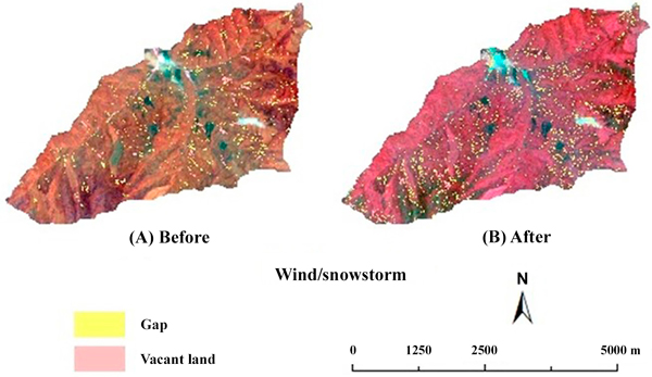
Fig. 2. The spatial patterns of gaps and vacant lands before (A) and after (B) the wind/snowstorm.
| Table 4. General characteristics of gaps and vacant lands before and after the wind/snowstorm and the flood disturbances. | |||||
| Characteristic | Wind/snowstorm | Flood | |||
| Before (2002) | After (2003) | Before (2011) | After (2014) | ||
| Gap | Fraction (%) | 3.64 | 5.1 | 3.14 | 2.71 |
| Mean size (m2) | 121 | 130 | 106 | 78 | |
| Density (ha–1) | 2.97 | 3.94 | 3.0 | 3.5 | |
| GNNI | 0.81 | 0.77 | 0.65 | 0.56 | |
| Vacant land | Fraction (%) | 0.26 | 0.27 | 0.22 | 1.10 |
| Mean size (m2) | 4488 | 4052 | 3780 | 4656 | |
| Number | 8 | 8 | 8 | 32 | |
| GNNI = gap nearest neighbor index | |||||
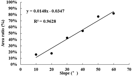
Fig. 3. Relationship between slope and area ratio of gaps induced by wind/snowstorm to total gaps, x: the upper limit of the slope classes, y: the area ratio of new gaps to total gaps.
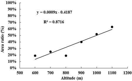
Fig. 4. Relationship between altitude and area ratio of gaps induced by wind/snowstorm to total gaps, x: the upper limit of the altitude classes, y: the area ratio of new gaps to total gaps.
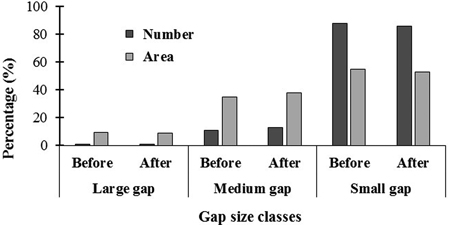
Fig. 5. The number and area percentages of gap in large, medium and small classes before and after the wind/snowstorm disturbance, x: gap size classes (divided by the ratio of gap diameter to the mean height of gap border trees, 0.23–0.73, 0.74–1.73 and 1.74–3.23 for small, medium and large gaps).
In the case of flood, both gaps and vacant lands patterns after flood (2014) were changed dramatically compared with those before the flood in 2011 (Fig. 6). After the flood, the GNNI dropped from 0.65 to 0.56. The gap fraction decreased by 14%, but the gap density increased by 17%. The vacant lands increased fivefold in area and fourfold in number (Table 4). The area ratio of new gaps to total gaps showed significantly positive correlations with slope (R2 = 0.89, p < 0.001; Fig. 7) but negative correlations with altitude (R2 = 0.92, p < 0.001; Fig. 8). Large and medium gaps decreased by 10% and 31% in area and 6% and 43% in number, respectively. However, the small ones promoted by 24% in area and by 10% in number. The ratio of small gaps to total gaps increased from 38% to 50% in area, 87% to 92% in number (Fig. 9).
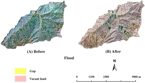
Fig. 6. The spatial patterns of gaps and vacant lands before (A) and after (B) the flood.
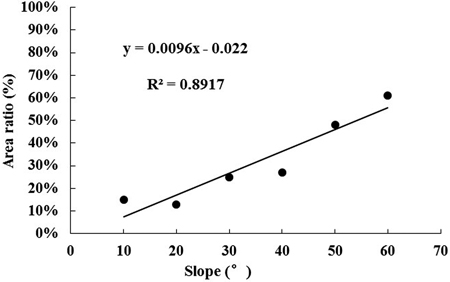
Fig. 7. Relationship between slope and area ratio of gaps induced by flood to total gaps, x: the upper limit of the slope classes, y: the area ratio of new gaps to total gaps.
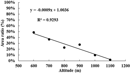
Fig. 8. Relationship between altitude and area ratio of gaps induced by flood to total gaps, x: the upper limit of the altitude classes, y: the area ratio of new gaps to total gaps.
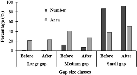
Fig. 9. The number and area percentages of gap in large, medium and small classes before and after the flood disturbance, x: gap size classes (divided by the ratio of gap diameter to the mean height of gap border trees, 0.23–0.73, 0.74–1.73 and 1.74–3.23 for small, medium and large gaps).
4 Discussion
The gap nearest neighbor index was decreased after both wind/snowstorm and flood disturbances, which suggested that the gap distribution tended to be more aggregated after disturbances regardless of the disturbance types, the same as indicated earlier by Woods (2004), Wolf (2005) and Frolking et al. (2009). For the wind/snowstorm, the area percentage of newly formed gaps increased with the increases of altitude and slope steepness, which implied that gaps induced by wind/snowstorm distributed intensively in the steep slopes with high elevations. Our previous research results indicated that the higher the altitude was, the larger the snowfall became (Li et al. 2005). The trees being loaded by heavy snow were more vulnerable to breakage during the winds (Zhu et al. 2006). In addition, trees growing on steep slopes usually have asymmetric crown and shallow roots, which increased the probability of canopy damage and uprooting (Li et al. 2005). Thus, it is no surprise that the amount of gaps increased with the height of altitude and the slope steepness. When it comes to flood, the areas proportion of newly formed gaps shown a positive correlation with slope steepness and a negative correlation with altitude. That is to say that the gaps were likely to aggregate in sites with steep slopes and low altitudes after the flood. These results were partly in accord with the conclusion reviewed by Frolking et al. (2009), who summarized that the zone disturbed by flood was concentrated to valleys. On the one hand, the flood water would have a dramatically increases not only in rate but also in quantity when it gathered in low altitude sites (Lin et al. 2011). Therefore, the forests there suffered stronger mechanical forces than those in high altitude sites. On the other hand, steep slopes were characterized by low stand density and thin soil depth, consequently, the forests there had less resistance to the flood. In summary, the flood tended to damage the forests on the sites with steep slopes and low altitudes, thus created clustered gaps.
Our results showed that the wind/snowstorm obviously increased both in gap fraction and gap density, while the flood mainly induced vacant lands. The results coincide with the conclusion that the wind/snowstorm, as a kind of low-intensity windstorm disturbance, induced less damages than high-intensity disturbances (Frolking et al. 2009), such as the flood in our study. Wind/snowstorms damaged trees by bending, uprooting, canopy damage, and stem breakage (Li et al. 2005; Zhu et al. 2006). Only the vulnerable trees, such as the low-taper trees (Zhu et al. 2006), those with rot diseases (Matlack et al. 1993), or those with large crowns but shallow root systems (Shorohova et al. 2009), were damaged by the wind/snowstorm. Thus, the wind/snowstorm usually caused individual tree-level death rather than the contiguous or group removal, creating gaps rather than vacant lands. For the flood, the formation of vacant lands might be attributed to two reasons. Firstly, floods in montane are usually triggered by intense rainfall and commonly accompanied with landslides. When the mechanical force of floodwater beyond forest intercepting capacity, the forests would be removed or swept by flood (Lin et al. 2011), which formed large area of vacant lands rather than gaps. In addition, the expansions of wind/snowstorm-induced gaps may be the other reason for the remarkable formation of vacant lands after the flood. Besides causing uprooting and then forming gaps, windstorms also weaken the gap-surrounding trees in many ways, such as reduction of branches, stem damage caused by falling of gap-makers, stress or breakage in the root system caused by stem bending (Allen 1992; Stathers et al. 1994). These storm-weakened trees are susceptible to mortality in further disturbances (Nagel and Diaci 2006; Vodde et al. 2011), causing gap expansion. Observation of gap closure processes conducted in the same study site showed that small gaps (canopy gap: 68–125 m2) would disappear after about ten years of formation because of lateral extension growth; but the medium and large gaps (canopy gap: 174–621 m2) would last much longer (Lu et al. 2015). Therefore, most of the medium and large gaps induced by the wind/snowstorm still existed in 2013 and were easily extended to vacant lands during the flood.
During the wind/snowstorm, the proportion of medium gaps increased. While, the flood promoted the ratio of small gaps. Other similar studies on mid-size windstorms in temperate forests have also documented that the number of mid-size gaps increased (Nagel and Diaci 2006; Peterson et al. 2013). The reasons why windstorms caused medium gap may be attributed to: on the one hand, the dominant trees with broad crowns and high heights were more vulnerable to wind/snowstorm (Zhu et al. 2006). Hence, wind/snowstorm-damaged trees could release more canopy space than those died from natural mortality or thinning (Woods 2004; Nagel and Svoboda 2008). On the other hand, the fall of dominant trees easily led a continuous fall of surrounding trees, just like dominos (Rentch et al. 2010). The secondary forest ecosystems usually have high stand density. So there is a high possibility of fall of dominant trees damaging the adjacent trees and causing synchronous mortality. The tension of liana plays a supplementary role in causing group tree fall. The liana usually twines around the dominated trees and increases the connections between adjacent trees. So the developed liana, such as Actinidia chinensis (Sieb. & Zucc.) Planch. ex Miq. in our study area, increased the possibility of group tree fall (Felton et al. 2006). As a result, multiple-tree-fall gaps (medium gaps) were common to find in the forests after wind/snowstorm. As to the disturbance of flood, the study conducted in Amazon claimed that flood might reduce the canopy heterogeneity caused by tree-fall gaps (Myster and Malahy 2012). This finding agreed with our results for the medium and large gaps, but reversed to us for small gaps. This is mainly because the severity of flood distributed heterogeneously in mountain region. In areas experiencing high intensity flood, forests with medium and large gaps may be swept to vacant lands when the dominant trees are removed. In some areas, low intensity flood cannot remove the dominant trees (Iles and Gleason 1994), uprooting of single tree became the major damage mode instead of integral sweeping. The trees in smaller sizes have less resistant to uprooting of single tree duo to their undeveloped root systems (Myster 2007). Moreover, the flood produced dead standing trees due to the mechanical damages and insufficient supplement of soil oxygen (Iles and Gleason 1994; Myster 2015). Small trees died in this way had few impacts on canopy openness, so only small gaps were created by the flood.
In conclusion, wind/snowstorms mainly created medium gaps in the sites with steep slopes and high altitudes, thereby promoting the spatial heterogeneity and resource availability. The prevailing of medium gaps may provide more opportunities for the regeneration of shade-tolerant species. Thus, the forest managers should concentrate more about how to use medium gaps to accelerate regeneration and succession of secondary forest ecosystems after the wind/snowstorm happened. The flood created more small gaps, which had few impacts on forest regeneration (Lu et al. 2015). But, it caused a large area of vacant lands, which may lead to a reverse succession in secondary forest ecosystems. So the foresters should consider more about how to accelerate forest restoration from vacant land through artificial promotion because the vegetation after flood cannot restore naturally within a short time. It is a pity that there is no comparison of the regeneration in gaps induced by the two disturbances in our study. Further research based on field survey may provide more detail information for foresters.
Acknowledgements
This study was financially supported by National Natural Science Foundation of China (31330016, 41371511). We thank Dr. Tian Gao and Mr. Tao Yan from Institute of Applied Ecology, Chinese Academy of Sciences for their helpful discussion. We also thank the chief editor of Silva Fennica Dr. Eeva Korpilahti and the anonymous reviewers for their valuable criticisms, suggestions and the detail revisions on our manuscript.
References
Allen J.R.L. (1992). Trees and their response to wind: mid Flandrian strong winds, Severn Estuary and inner Bristol Channel, southwest Britain. Philosophical Transactions Biological Sciences 338(1286): 335–364. https://doi.org/10.1098/rstb.1992.0154.
Balslev H., Luteyn J.L., Ligaard B., Holm-Nielsen L.B. (1987). Composition and structure of adjacent unflooded and floodplain forest in Amazonian Ecuador. Opera Botanica 92: 37–57.
Baumann M., Ozdogan M., Wolter P.T., Krylov A., Vladimirova N., Radeloff V.C. (2014). Landsat remote sensing of forest windfall disturbance. Remote Sensing of Environment 143: 171–179. https://doi.org/10.1016/j.rse.2013.12.020.
Bouchard M., Kneeshaw D.D., Bergeron Y. (2006). Forest dynamics after successive spruce budworm outbreaks in mixed-wood forests. Ecology 87: 2319–2329. https://doi.org/10.1890/0012-9658(2006)87[2319:FDASSB]2.0.CO;2.
Boyd D.S., Hill R.A., Hopkinson C., Baker T.R. (2013). Landscape-scale forest disturbance regimes in southern Peruvian Amazonia. Ecological Applications 23: 1588–1602. https://doi.org/10.1890/12-0371.1.
Brown N. (1993). The implications of climate and gap microclimate for seedling growth conditions in a Bornean lowland rain forest. Journal of Tropical Ecology 9(2): 153–168. https://doi.org/10.1017/S0266467400007136.
Cannon J.B., Hepinstall-Cymerman J., Godfrey C.M., Peterson C.J. (2016). Landscape-scale characteristics of forest tornado damage in mountainous terrain. Landscape Ecology 31(9): 2097–2114. https://doi.org/10.1007/s10980-016-0384-8.
Clinton B.D., Baker C.R. (2000). Catastrophic windthrow in the southern Appalachians: characteristics of pits and mounds and initial vegetation responses. Forest Ecology and Management 126(1): 51–60. https://doi.org/10.1016/S0378-1127(99)00082-1.
Felton A., Felton A.M., Wood J., Lindenmayer D.B. (2006). Vegetation structure, phenology, and regeneration in the natural and anthropogenic tree-fall gaps of a reduced-impact logged subtropical Bolivian forest. Forest Ecology and Management 235(1–3): 186–193. https://doi.org/ 10.1016/j.foreco.2006.08.011.
Frolking S., Palace M.W., Clark D.B., Chambers J.Q., Shugart H.H., Hurtt G.C. (2009). Forest disturbance and recovery: a general review in the context of spaceborne remote sensing of impacts on aboveground biomass and canopy structure. Journal of Geophysical Research 114: G00E02. https://doi.org/10.1029/2008jg000911.
Gagnon J.L., Jokela E.J., Moser W.K., Huber D.A. (2004). Characteristics of gaps and natural regeneration in mature longleaf pine flatwoods ecosystems. Forest Ecology and Management 187(2–3): 373–380. https://doi.org/10.1016/j.foreco.2003.07.002.
Garbarino M., Borgogno Mondino E., Lingua E., Nagel T.A., Dukić V., Govedar Z., Motta R. (2012). Gap disturbances and regeneration patterns in a Bosnian old-growth forest: a multispectral remote sensing and ground-based approach. Annals of Forest Science 69(5): 617–625. https://doi.org/10.1007/s13595-011-0177-9.
Iles J., Gleason M. (1994). Understanding the effects of flooding on trees. American Nurseryman.
Kramer K., Brang P., Bachofen H., Bugmann H., Wohlgemuth T. (2014). Site factors are more important than salvage logging for tree regeneration after wind disturbance in Central European forests. Forest Ecology and Management 331: 116–128. https://doi.org/10.1016/j.foreco.2014.08.002.
Krasny M.E., Whitmore M.C. (1992). Gradual and sudden forest gaps in Allegheny northern hardwood forests. Canadian Journal of Forest Research 22(2): 139–143. https://doi.org/10.1139/x92-019.
Landis J.R., Koch G.G. (1977). The measurement of observer agreement for categorical data. Biometrics 33(1): 159–174. https://doi.org/ 10.2307/2529310.
Li X., Zhu J., Wang Q., Liu Z. (2005). Forest damage induced by wind/snow: a review. Acta Ecologica Sinica 25: 148–157.
Li X., Zhu J., Wang Q., Liu Z., Hou C., Yang H. (2004). Snow/wind damage in natural secondary forests in Liaodong mountainous regions of Liaoning Province. Chinese Journal of Applied Ecology 15(6): 941–946.
Lin Y., Chen J., Wu C., Chen C., Liu J., Xiao Y., Lin S. (2011). The response of forest to persistent super rainstorm and its restoration countermeasures in Northern Fujian Province. Chinese Agricultural Science Bulletin 27: 13–16.
Lu D., Zhu J., Sun Y., Hu L., Zhang G. (2015). Gap closure process by lateral extension growth of canopy trees and its effect on woody species regeneration in a temperate secondary forest, Northeast China. Silva Fennica 49(5) article 1310. https://doi.org/10.14214/sf.1310.
Marra D.M., Chambers J.Q., Higuchi N., Trumbore S.E., Ribeiro G.H.P.M., dos Santos J., Negron-Juarez R.I., Reu B., Wirth C. (2014). Large-scale wind disturbances promote tree diversity in a central Amazon forest. Plos One 9(11): e114769. https://doi.org/10.1371/journal.pone.0103711.
Marthews T.R., Burslem D.F., Phillips R.T., Mullins C.E. (2008). Modelling direct radiation and canopy gap regimes in tropical forests. Biotropica 40: 676–685. https://doi.org/10.1111/j.1744-7429.2008.00431.x.
Martinezramos M., Alvarezbuylla E., Sarukhan J. (1989). Tree demography and gap dynamics in a tropical rain-forest. Ecology 70: 555–558. https://doi.org/10.2307/1940203.
Matlack G.R., Gleeson S.K., Good R.E. (1993). Treefall in a mixed oak-pine coastal plain forest: immediate and historical causation. Ecology 74(5): 1559–1566. https://doi.org/10.2307/1940083.
McCarthy J. (2001). Gap dynamics of forest trees: a review with particular attention to boreal forests. Environmental Reviews 9(1): 1–59. https://doi.org/10.1139/a00-012.
Muscolo A., Bagnato S., Sidari M., Mercurio R. (2014). A review of the roles of forest canopy gaps. Journal of Forestry Research 25(4): 725–736. https://doi.org/10.1007/s11676-014-0521-7.
Myster R.W. (2007). Interactive effects of flooding and forest gap formation on tree composition and abundance in the peruvian Amazon. Folia Geobotanica 42(1): 1–9. https://doi.org/10.1007/bf02835099.
Myster R.W. (2010). Flooding gradient and treefall gap interactive effects on plant community structure, richness, and alpha diversity in the Peruvian Amazon. Ecotropica 16: 43–49.
Myster R.W. (2015). Flooding × tree fall gap interactive effects on blackwater forest floristics and physical structure in the Peruvian Amazon. Journal of Plant Interactions 10(1): 126–131. https://doi.org/10.1080/17429145.2015.1029018.
Myster R.W., Malahy M.P. (2012). Testing aggregation hypotheses among neotropical trees and shrubs: results from a 50-ha plot over 20 years of sampling. Revista De Biologia Tropical 60(3): 1015–1023. https://doi.org/10.15517/rbt.v60i3.1754.
Nagel T.A., Diaci J. (2006). Intermediate wind disturbance in an old-growth beech-fir forest in southeastern Slovenia. Canadian Journal of Forest Research 36(3): 629–638. https://doi.org/10.1139/x05-263.
Nagel T.A., Svoboda M. (2008). Gap disturbance regime in an old-growth Fagus-Abies forest in the Dinaric Mountains, Bosnia-Herzegovina. Canadian Journal of Forest Research 38(11): 2728–2737. https://doi.org/10.1139/x08-110.
Peterson C.J., Krueger L.M., Royo A.A., Stark S., Carson W.P. (2013). Disturbance size and severity covary in small and mid-size wind disturbances in Pennsylvania northern hardwoods forests. Forest Ecology and Management 302: 273–279. https://doi.org/10.1016/j.foreco.2013.03.045.
Potter C. (2014). Ten years of forest cover change in the Sierra Nevada detected using Landsat satellite image analysis. International Journal of Remote Sensing 35(20): 7136–7153. https://doi.org/10.1080/01431161.2014.968687.
Rentch J.S., Schuler T.M., Nowacki G.J., Beane N.R., Ford W.M. (2010). Canopy gap dynamics of second-growth red spruce-northern hardwood stands in West Virginia. Forest Ecology and Management 260(10): 1921–1929. https://doi.org/10.1016/j.foreco.2010.08.043.
Richards J.D., Hart J.L. (2011). Canopy gap dynamics and development patterns in secondary Quercus stands on the Cumberland Plateau, Alabama, USA. Forest Ecology and Management 262(12): 2229–2239. https://doi.org/10.1016/j.foreco.2011.08.015.
Rugani T., Diaci J., Hladnik D. (2013). Gap dynamics and structure of two old-growth beech forest remnants in Slovenia. PLoS One 8(1): e52641. https://doi.org/10.1371/journal.pone.0052641.
Salvador-Van Eysenrode D., Bogaert J., Van Hecke P., Impens I. (1998). Influence of tree-fall orientation on canopy gap shape in an Ecuadorian rain forest. Journal of Tropical Ecology 14(6): 865–869. https://doi.org/10.1017/S0266467498000625.
Shorohova E., Kuuluvainen T., Kangur A., Jõgiste K. (2009). Natural stand structures, disturbance regimes and successional dynamics in the Eurasian boreal forests: a review with special reference to Russian studies. Annals of Forest Science 66(2): 201. https://doi.org/10.1051/forest/2008083.
Stathers R.J., Rollerson T.P., Mitchell S.J. (1994). Windthrow handbook for British Columbia forests. Research Program Working Paper No. 9401. British Columbia Ministry of Forest.
Torimaru T., Itaya A., Yamamoto S.-I. (2012). Quantification of repeated gap formation events and their spatial patterns in three types of old-growth forests: analysis of long-term canopy dynamics using aerial photographs and digital surface models. Forest Ecology and Management 284: 1–11. https://doi.org/10.1016/j.foreco.2012.07.044.
Turner M.G., Tinker D.B. (2003). Surprises and lessons from the 1988 Yellowstone fires. Frontiers in Ecology and the Environment 1: 351–358. https://doi.org/10.2307/3868187.
Veblen T.T., Lara A. (1992). Disturbance and forest dynamics along a transect from Andean rain forest to Patagonian shrubland. Journal of Vegetation Science 3: 507–520. https://doi.org/10.2307/3235807.
Vepakomma U., St-Onge B., Kneeshaw D. (2008). Spatially explicit characterization of boreal forest gap dynamics using multi-temporal lidar data. Remote Sensing of Environment 112(5): 2326–2340. https://doi.org/10.1016/j.rse.2007.10.001.
Vodde F., Jõgiste K., Kubota Y., Kuuluvainen T., Köster K., Lukjanova A., Metslaid M., Yoshida T. (2011). The influence of storm-induced microsites to tree regeneration patterns in boreal and hemiboreal forest. Journal of Forest Research 16(3): 155–167. https://doi.org/10.1007/s10310-011-0273-6.
Vogt J., Kautz M., Fontalvo Herazo M.L., Triet T., Walther D., Saint-Paul U., Diele K., Berger U. (2013). Do canopy disturbances drive forest plantations into more natural conditions? – A case study from Can Gio Biosphere Reserve, Viet Nam. Global and Planetary Change 110(B): 249–258. https://doi.org/10.1016/j.gloplacha.2011.09.002.
Watt A.S. (1947). Pattern and process in the plant community. Journal of Ecology 35(1/2): 1–22. https://doi.org/10.2307/2256497.
Whitmore T. (1989). Canopy gaps and the two major groups of forest trees. Ecology 70: 536–538. https://doi.org/10.2307/1940195.
Wolf A. (2005). Fifty year record of change in tree spatial patterns within a mixed deciduous forest. Forest Ecology and Management 215(1–3): 212–223. https://doi.org/10.1016/j.foreco.2005.05.021.
Woods K.D. (2004). Intermediate disturbance in a late-successional hemlock northern hardwood forest. Journal of Ecology 92: 464−476. https://doi.org/10.1111/j.0022-0477.2004.00881.x.
Yan Q.L., Zhu J.J., Zhang J.P., Yu L.Z., Hu Z.B. (2010). Spatial distribution pattern of soil seed bank in canopy gaps of various sizes in temperate secondary forests, Northeast China. Plant and Soil 329(1–2): 469–480. https://doi.org/10.1007/s11104-009-0172-1.
Yan Q.L., Zhu J.J., Yu L.Z. (2012). Seed regeneration potential of canopy gaps at early formation stage in temperate secondary forests, Northeast China. Plos One 7(6): e39502. https://doi.org/10.1371/journal.pone.0039502.
Yang K., Shi W., Zhu J.J. (2012). The impact of secondary forests conversion into larch plantations on soil chemical and microbiological properties. Plant and Soil 368(1–2): 535–546. https://doi.org/10.1007/s11104-012-1535-6.
Young T.P., Hubbell S.P. (1991). Crown asymmetry, treefalls, and repeat disturbance of broad-leaved forest gaps. Ecology 72: 1464–1471. https://doi.org/10.2307/1941119.
Zhu J.J., Liu Z.G., Li X.F., Matsuzaki T., Gonda Y. (2004). Review: effects of wind on trees. Journal of Forestry Research 15(2): 153–160. https://doi.org/10.1007/BF02856753.
Zhu J.J., Li X.F., Liu Z.G., Cao W., Gonda Y., Matsuzaki T. (2006). Factors affecting the snow and wind induced damage of a montane secondary forest in northeastern China. Silva Fennica 40(1): 37–51. https://doi.org/10.14214/sf.351.
Zhu J.J, Mao Z., Hu L., Zhang J. (2007). Plant diversity of secondary forests in response to anthropogenic disturbance levels in montane regions of northeastern China. Journal of Forest Research 12(6): 403–416. https://doi.org/10.1007/s10310-007-0033-9.
Zhu J.J., Zhang G., Wang G.G., Yan Q., Lu D., Li X., Zheng X. (2015). On the size of forest gaps: can their lower and upper limits be objectively defined? Agricultural and Forest Meteorology 213: 64–76. https://doi.org/10.1016/j.agrformet.2015.06.015.
Total of 58 references.
Send to email
