Jānis Donis,
Māra Kitenberga  ,
Guntars Šņepsts,
Roberts Matisons,
Juris Zariņš,
Āris Jansons
,
Guntars Šņepsts,
Roberts Matisons,
Juris Zariņš,
Āris Jansons
The forest fire regime in Latvia during 1922–2014
Donis J., Kitenberga M., Šņepsts G., Matisons R., Zariņš J., Jansons Ā. (2017). The forest fire regime in Latvia during 1922–2014. Silva Fennica vol. 51 no. 5 article id 7746. https://doi.org/10.14214/sf.7746
Highlights
- Climate effects and human influence on forest fire activity in Latvia was assessed using time-series analysis
- Drought conditions during summer season had the strongest effect on fire activity of tested climatic variables
- Negative trends and spatial distribution pattern of fire activity suggests of prevailing human influence on forest fire regime over the 20th century.
Abstract
Fire as disturbance of forests has an important ecological and economical role in boreal and hemiboreal forests. The occurrence of forest fires is both climatically and anthropogenically determined and shifts in fire regimes are expected due to climate change. Although fire histories have been well documented in boreal regions, there is still insufficient information about fire occurrence in the Baltic States. In this study, spatio-temporal patterns and climatic drivers of forest fires were assessed by means of spatial and time-series analysis. The efficiency of Canadian Fire Weather (FWI) indices as indicators for fire activity was tested. The study was based on data from the literature, archives, and the Latvian State Forest service database. During the period 1922–2014, the occurrence and area affected by forest fires has decreased although the total area of forest land has nearly doubled, suggesting improvement of the fire suppression system as well as changes in socioeconomic situation. The geographical distribution of forest fires revealed two pronounced clusters near the largest cities of Riga and Daugavpils, suggesting dominance of human causes of ignitions. The occurrence of fires was mainly influenced by drought. FWI appeared to be efficient in predicting the fire occurrence: 23–34% of fires occurred on days with a high or extremely high fire danger class, which overall had a relative occurrence of only 4.3–4.6%. During the 20th century, the peak of fire activity shifted from May to April, probably due to global warming and socioeconomic reasons. The results of this study are relevant for forest hazard mitigation and development of fire activity prediction system in Latvia.
Keywords
forest disturbance;
fire regime;
hemiboreal zone;
spatial analysis
- Donis, LSFRI “Silava”, Rigas str. 111, Salaspils, Latvia, LV2169 E-mail janis.donis@silava.lv
-
Kitenberga,
LSFRI “Silava”, Rigas str. 111, Salaspils, Latvia, LV2169
E-mail
mara.kitenberga@gmail.com
- Šņepsts, LSFRI “Silava”, Rigas str. 111, Salaspils, Latvia, LV2169 E-mail guntars.snepsts@silava.lv
- Matisons, LSFRI “Silava”, Rigas str. 111, Salaspils, Latvia, LV2169 E-mail robism@inbox.lv
- Zariņš, LSFRI “Silava”, Rigas str. 111, Salaspils, Latvia, LV2169 E-mail juris.zarins@silava.lv
- Jansons, LSFRI “Silava”, Rigas str. 111, Salaspils, Latvia, LV2169 E-mail aris.jansons@silava.lv
Received 7 June 2017 Accepted 16 October 2017 Published 20 October 2017
Views 120349
Available at https://doi.org/10.14214/sf.7746 | Download PDF

1 Introduction
Forest fires are a part of the natural disturbance regime in boreal and hemiboreal and boreal forests, shaping landscape patterns, vegetation dynamics, and biodiversity (Granström 2001; Niklasson and Drakenberg 2001; Kalnina et al. 2015; Jogiste et al. 2017). In addition to their ecological importance, forest fires have strong socio-economic effects, including economic costs and displacement of people from their homes (Tedim et al. 2015). Therefore, information on the occurrence of forest fires and environmental factors affecting them is crucial for sustainable forest management, including the development of a fire prevention policy.
On the largest scale, fire activity is driven by the prevailing climatic conditions (Bowman et al. 2009; Drobyshev et al. 2016; Venäläinen et al. 2014). Climate influences vegetation patterns and determines the length of the fire season (Carvalho et al. 2011); however, in the short term, weather drives fire ignition, behaviour, and spread (Wotton and Beverly 2007). Fires affect climate through the change of vegetation structure, surface albedo, and release of aerosols, thus creating a feedback loop (Bowman et al. 2009; Bowman et al. 2014). In northern Europe, studies have reported strong S–N gradients in the length of fire cycles (Päätalo 1998; Drobyshev et al. 2012), likely reflecting forcing of diverse climatic systems on regional fire activity (Drobyshev et al. 2012). In the northern part of Sweden, fire activity has been clearly related to variations in Atlantic sea surface temperatures, while in the southern part, this pattern is weakly apparent (Drobyshev et al. 2016); hence, fire activity has regional specificity (Drobyshev et al. 2012).
The knowledge of and improved estimates of climatic drivers on fire activity is particularly important in the context of ongoing climatic change (Bowman et al. 2009). Abatzoglou and Williams (2016) presented an estimate that climate change may have increased fire-affected areas by 4.2 million ha in the western USA during 1984–2015. In southern and eastern Europe during the past few decades, the frequency of increased forest fire danger conditions has been rising (Venäläinen et al. 2014). In northern Europe, the occurrence of large ( >10 ha) forest fires is predicted to at least double by the end of the 21st century (Lehtonen et al. 2016). With increasing fire risks in the near future, information about past fire regimes is a valuable source of information that can be used for fire hazard predictions and mitigation.
During the past few centuries, spatio-temporal characteristics of fire regimes have been strongly influenced by land-use changes (Granström and Niklasson 2008; Bowman et al. 2014). In Latvia, slash-and-burn agriculture, which is associated with increased forest fire occurrence (Granström and Niklasson 2008), was widely practiced until the late 19th century (Dumpe 1999) as was the case in Estonia (Jääts et al. 2010) and Sweden (Granström and Niklasson 2008). Organised fire suppression systems started to develop in the late 19th and early 20th centuries, when the market value of timber increased, resulting in a considerable decrease in forest fires (Saliņš 1999; Dumpe 1999). During the 20th century, due to socio-political reasons (Jepsen et al. 2015), forested area has substantially increased from 17 300 km2 in 1923 (Matīss 1987) to 30 700 km2 in 2015 (according to the Latvian State Forest Service (LSFS)), thus increasing the probability of forest fires. Today, according to data from the LSFS, the majority (95%) of forest fires are of anthropogenic origin; however, weather conditions primarily determine their severity and magnitude (Wotton 2009). Although forest fire regimes have been widely studied in Fennoscandia, there is still scarce information about climatic drivers and fire activity in the hemiboreal forest zone, particularly the eastern Baltic region. The aim of this study was to assess spatio-temporal patterns and climatic drivers of forest fire regimes in Latvia during the 20th century.
We hypothesized that the spatial pattern of fires is anthropogenically determined, while fire occurrence and the area burned are mainly climatically driven.
2 Materials and methods
2.1 Study area and datasets
Latvia is situated in the hemiboreal forest zone, 56°58´N, 21°28´E (Ahti et al. 1968) and according to the Latvian State Forest Service (LSFS), today 52% of its territory is covered by forests. Scots pine (Pinus silvestris L.), birch (Betula pendula Roth and B. pubescens Ehrh.), and Norway spruce (Picea abies (L.) H. Karst.) are the most common tree species and comprised 26.9%, 28.2%, and 18.3% of total stand area, respectively. Most of the forests (57%) occur on dry mineral soils, 24% on drained soils, 10% on wet mineral soils, and 9% on peat soils. The climate is temperate continental (Lindner et al. 2010); prevailing westerlies bring moist maritime air masses from the Atlantic ocean (Dravniece 2003). Continentality increases eastwards with increasing distance from the Baltic Sea (Briede 2016). According to data from the Latvian Environment, Geology, and Meteorology Centre, the mean annual temperature during 1950–2003 was 5.9 °C, and January and July were the coldest and the warmest months with a mean temperature of −4.7 °C and +17.0 °C, respectively. The mean annual precipitation was 667 mm and most of it fell during the summer period (June–September). The length of the period when the mean diurnal temperature was >5 °C extended for 175–195 days. The mean annual air humidity was 81% and the mean monthly air humidity ranged from 71–88 % in May and December, respectively. During the fire seasons (March–October) of 1980–2009, the mean annual number of days with precipitation ranged 103–118.
Country-wide annual and monthly forest fire data for the period 1922–1974 were obtained from published sources (Delle 1930, 1932, 1934, 1935; Upītis 1927, 1940; Stunda 1944; Kronītis 1990). Data for 1940, 1941, and 1944 were lacking. Country-wide daily forest-fire statistics for the periods 1975–1984 and 2004–2014 were obtained from the archives of the Ministry of Forestry and Forest Industry and LSFS database.
Daily meteorological data (mean, max, min temperatures, relative humidity, precipitation, wind speed) for the period 1975–2014 were obtained from the Latvian Environment, Geology and Meteorology Centre. Monthly data (mean temperatures, precipitation sums, potential evapotranspiration (PET)) for the period 1922–2014 were obtained from the Climatic Research Unit high-resolution gridded dataset repository CRU TS 3.21 Harris et al. (2014); country-wide mean values were used.
2.2 Data analysis
To assess the significance of temporal trends in fire activity (number and total burned area), a non-parametric Mann-Kendal test was used (Helsel and Hirsch 2002). Distribution-free tests are widely used to analyse natural time series (Hamed 2009). The differences in seasonal (monthly) distribution of number of forest fires between the periods for which data were available (1933–1939, 1975–1984, 2007–2014), were assessed by the Chi-square test (Sokal and Rohlf 1995).
To assess spatial pattern of fire occurrence in Latvia, a grid of 12.5×12.5 km2 was used, according to the TKS93_25000 coordinate system, and global and local spatial statistics were applied. To assess global clustering, a spatial autocorrelation index (Global Moran’s I statistics) was calculated; to assess local clustering, a Hot Spot analysis (Getis-Ord G*) (Getis and Ord 1992) was used. Statistically significant G* values indicate the intensity of clustering; high positive values indicate a hot spot, namely a highly clustered region, while cold spots are regions with low clustering.
The Canadian Forest Fire Weather Index (FWI), which aggregates fuel and soil moisture; hence represents burnability (Van Wagner and Pickett 1985), was used to assess the effect of weather conditions on fire activity. The FWI has been successfully used for fire prediction in Finland (Tanskanen and Venäläinen 2008) as well as in the Eastern Mediterranean region (Papakosta and Straub 2016). In addition, the FWI has been successfully applied in studies assessing the potential influence of climate change on fire activity (Venäläinen et al. 2014; Flannigan et al. 2016) and it has been implemented in the European Forest Fire Information System (Di Giuseppe et al. 2016). We used arbitrarily adjusted FWI classes of Alexander and De Groot (1988) and Vajda et al. (2014) as follows: very low (0.0–5.0), low (5.1–10.0), moderate (10.1–17.0), high (17.1–30.0), extremely high (≥30.1). For each fire event (1975–1984 and 2004–2014), FWI daily values were calculated based on averaged daily means of meteorological data from the two local (<20 km) weather stations. A Kruskal-Wallis ANOVA with the z’ post-hoc test (Wayne 1990) was used to compare fire occurrence according to the FWI fire danger classes.
The fire rotation metric, which indicated the period (in years) needed for the whole studied territory to burn (Van Wagner 1978), was calculated to describe the spatial extent of fire activity. The fire rotation was calculated for the whole studied period 1922–2014 and for sub-periods (1922–1939, 1945–1964, 1965–1989, and 1990–2014) within the studied period.
The time series analysis approach (Sokal and Rohlf 1995) was applied to assess the climatic drivers of fire activity. Response function and correlation analysis were used to determine relationships between monthly climatic variables obtained from CRU TS 3.21 dataset (Harris et al. 2014) and the number and area of forest fires in Latvia. The analyses were developed to reconstruct relationships between climatic variables and tree-ring growth (Blasing et al. 1984); however, it can be applied to different annually resolved proxies (Zang and Biondi 2015). The bootstrapped confidence intervals were used to obtain the statistical significance of the observed relationships at α = 0.05. The tested climatic variables were mean monthly temperatures, sum of monthly precipitation, and Standardized Precipitation Evapotranspiration Index (SPEI) for the fire season (March–October). The SPEI is a multiscalar drought index, which is based on water balance (Vicente-Serrano et al. 2010) that was calculated with respect to the previous 3 months. The index allows for a comparison of drought variations through time and space. Due to its multiscalar characteristics, it has been considered to be superior over the self-calibrated Palmer Drought Severity Index (PDSI) and the Standardized Precipitation Index (SPI) (Beguería et al. 2014).
The data analysis was conducted in the R programming environment (R Core Team 2016) using the libraries: “treeclim” (Zang and Biondi 2015) and “SPEI” (Beguería et al. 2013). Spatial analyses were conducted in ArcMap 10.1.
3 Results
During 1922–2014 in Latvia, 56 521 forest fires occurred, affecting 94 410 ha of forest land. The mean ± standard error occurrence of forest fires was 628.0 ± 38.4 events per year, while the mean annual burned area was 1049.0 ± 194.5 ha per year. Accordingly, the mean fire rotation period (FRP) was 2.1×10³ years. However, among the sub-periods, it differed significantly (p-value < 0.05): in 1922–1939, 1945–1964, 1965–1989, and 1990–2014 it was 1.3×10³, 1.1×10³, 8.8×10³, and 3.2×10³, respectively. Still, the FRPs were similar in 1922–1939 and 1945–1964. The highest number of fires occurred in 1951, 1963, and 2006, when 1169, 1489, and 1929 events were recorded, respectively. The highest annual area of forest fires was recorded in 1945, 1947, 1963, and 1992 when 7017, 7033, 12 013, and 8412 ha burned, respectively. During the 20th century, a significant decreasing trend in the burned area (Z = −4.33, p-value < 0.001) and fire occurrence (Z = −2.03, p-value < 0.05) were observed (Fig. 1). The occurrence and the total area of forest fires were significantly correlated (r = 0.45, p-value < 0.05). Since 1946, the annual variation (variation coefficient) in forest fire occurrence has increased significantly (t = 6.104, p-value < 0.01). During the 20th century, the mean fire size (r = –0.364, p-value < 0.001) has decreased (Fig. 1C). However, the magnitude of forest fires has been variable, as indicated by significant differences between the two periods 1975–1984 and 2004–2014 (Chi-square = 26.59, p-value < 0.01) (Fig. 2). The proportion of large fires (1–10 ha) increased from 29.1% (1975–1984) to 49.5% (2004–2014), while the proportion of small fires (<0.1 ha) decreased from 70.2% to 48.8%, respectively.
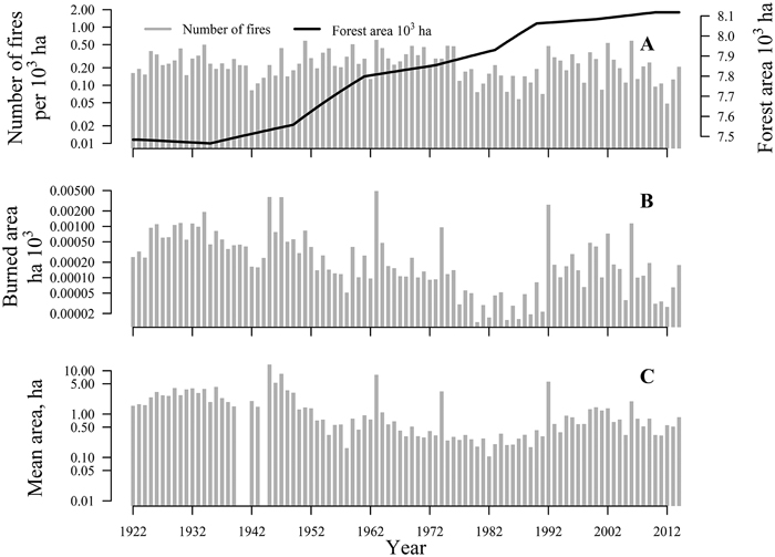
Fig. 1. The area of forest land, number of forest fires (A), burned area (B), and the mean fire size (C) in Latvia during the period 1922–2014. Note that the y-axes are logarithmic.
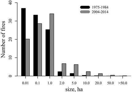
Fig. 2. Distribution of mean fire size classes for the periods 1975–1984 and 2004–2014.
Over the 20th century, fire occurrence had a distinct seasonal pattern (Fig. 3). The occurrence of fires peaked in May, resulting in a positively skewed distribution. The distribution of seasonal fire occurrence was similar in the sub-periods 1933–1939 and 1975–1984 while in 2007–2014, a significantly higher number of early spring (March, April) fires were recorded in comparison to the previous periods 1933–1939 and 1975–1984, with a χ2 = 22.91, p-value < 0.05, χ2 = 50.61, p-value < 0.05, respectively.
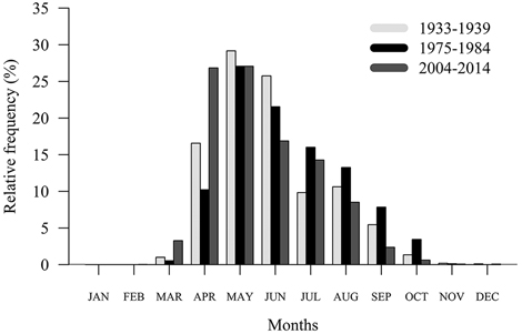
Fig. 3. Monthly distribution of fire occurrence in the periods 1933–1939, 1975–1984, and 2007–2014.
The annual variation in occurrence of forest fires and burned area were affected by climatic variables (Fig. 4). Of the tested climatic variables, 11 showed significant correlations, yet 4 showed significant response function coefficients. Fire occurrence was correlated to water balance (SPEI) and precipitation during the June–October period, as well as mean temperature in late summer (August–September). Response function analysis showed that precipitation in June and SPEI in June–August had the strongest effect on fire occurrence. In contrast, the burned area was clearly less affected by the tested climatic variables, because only the mean air temperature in June showed a weak, but significant, correlation.
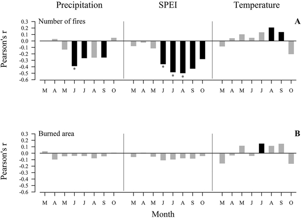
Fig. 4. Response function (asterisk) and Pearson’s correlation (bars) coefficients between fire activity and climatic variables: monthly cumulative precipitation, mean temperature, and standardised precipitation evotranspiration index (SPEI) for the period 1923–2012. Significant correlations (at α= 0.05) are shown in black; asterisk indicate significant (at α= 0.05) response function coefficient.
The fire-weather season and occurrence of fires were described according to the FWI system (Fig. 5). In both periods (1975–1984 and 2007–2012) the distribution of days described by FWI danger classes was similar and for the majority of days (>65%), the fire danger was rated “very low”, while in other fire danger classes the proportion of days was considerably lower, ranging from 0.1% to 16% (Fig. 5A). The proportion of fires occurring on days with a “high” and “extremely high” FWI fire danger class increased from 23.4% (1975–1984) to 33.8% (2007–2012), while in other FWI fire danger classes it decreased (Fig. 5B). The mean size of fires gradually increased with increasing fire danger values (Fig. 5C); particularly, the mean size of fires in the “very low”FWI fire danger class was significantly (p-value < 0.01) lower in comparison to the “high” and “extremely high” FWI fire danger class.
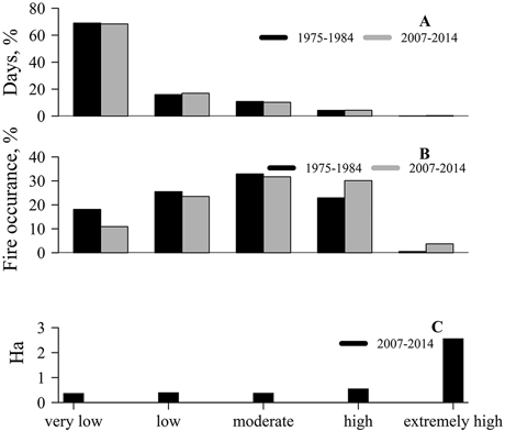
Fig. 5. Distribution of days (A) and fire occurrence (B) in the Canadian Fire Weather Index (FWI) danger classes during 1975–1984 and 2007–2014. Distribution of mean fire size (C) in the FWI danger classes during 2007–2014.
The locations of forest fires during 2007–2014 were spatially clustered, as indicated by a significant positive spatial autocorrelation (Moran’s I = 0.51; Z = 17.2; p-value < 0.001). Most of the forest fires were located near urban areas, particularly near the largest cities: Riga, Daugavpils, and Ventspils (Fig. 6). In total, 15 significant (p-value < 0.05) forest fire occurrence hot-spots were distinguished, and the majority were located close to Riga and Daugavpils, but no significant cold-spots were detected.
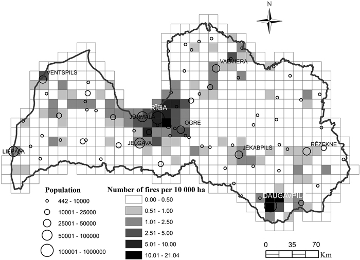
Fig. 6. The spatial clustering pattern of forest fire occurrence per 100 00 ha per year 2007–2014.
4 Discussion
Over the 20th century in Latvia, fire activity has gradually decreased (Fig. 1). Similar long-term trend of reduced fire occurrence has been observed in Fennoscandia over the same period (Wallenius 2011; Drobyshev et al. 2012). Improvement of the fire suppression system and forest road network (Saliņš 1999; Granström and Niklasson 2008), as well as continuous investments in fire surveillance system (Vasiļevskis 2007) most likely has helped to limit fire activity in Latvia; similarly, to Fennoscandia (Wallenius 2011; Drobyshev et al. 2012). Still, some bias in the fire data might be introduced by the political conditions, particularly regarding the data about fire area. In the former political system, the area of fires was the measure of efficiency of forest management, hence official statistics might underestimate the actual situation. In addition, the thresholds of forest fires to be recorded have been slightly shifting (Saliņš 1999).
Over the last few decades, an increase of fire magnitude was observed (Fig. 2). Similar trends of increased fire activity have been observed in the Mediterranean region (Turco et al. 2016) and Poland (Szczygieł et al. 2008), which could be caused by ongoing climate change and socioeconomic reasons (Turco et al. 2016). Our results of FRP (2.1×10³ years) are similar to those obtained by Drobyshev et al. (2012) in southern Sweden. Considering possible bias, still the extended FRP during 1975–1984 (8.8×10³ years) could be related to wetter (SPEI index was on average by 19% lower compared to the preceding and following periods, respectively) weather conditions (Harris et al. 2014), as also indicated by the number of fires (Figs. 1A,4).
Over the 20th century, the peak of forest fire seasonal occurrence has shifted towards earlier in spring (Fig. 3). A similar peak of seasonal fire occurrence has been observed in southern Sweden (Drobyshev et al. 2012), Finland (Lehtonen et al. 2016), and Poland (Ubysz et al. 2006). The observed changes in timing and duration of fire seasons have been attributed to climate change (Westerling et al. 2006; Szczygieł et al. 2008; Turco et al. 2016). Increasing mean air temperature in spring (Briede 2016) causes earlier snowmelt and drying of fuels, consequently promoting earlier ignition of fire. Spring forest fires usually start from burnings of easily flammable grasslands that spread into forests; nevertheless, the origin of these fires is mainly anthropogenic (Drobyshev et al. 2012; De Groot et al. 2013; Lehtonen et al. 2016). After the collapse of the former Soviet Union, approximately 42% of the agriculture land was abandoned in Latvia (Prishchepov et al. 2012) and consequently, there were increased burnings of abandoned lands, which likely facilitated forest fire occurrences in the spring.
Climatic conditions had a significant effect on the variability of fire activity in Latvia. During the summer season, drought conditions, which determines the flammability of fuels, had the strongest effect on fire occurrence (Fig. 4). Similar, drought-driven fire activity has been observed in Scandinavia (Drobyshev et al. 2012). In spring, when the fire occurrence was the highest (Fig. 3), the relationships with climatic variables were insignificant. Because the spring fires predominantly start from grassland burnings (De Groot et al. 2013; Lehtonen et al. 2016) the water-balance might be of less importance since a grassland fire can be initiated soon after snowmelt and a short period of drier weather conditions (Drobyshev et al. 2012). Human-caused changes in spatial and temporal characteristics of fire activity reduce the explained variability in fire-climate relationships (Drobyshev et al. 2012). For example, in Finland, climatic variables explained only half of the variability in annually burned area (Lehtonen et al. 2016). Similarly, in our study, a weak correlation between climatic variables and burned area (Fig. 4B) indicates that the majority of fires are suppressed in a timely and effective manner after the initial attack by firefighters. Still, years with exceptionally high fire occurrences (1951, 1963, 2006) and total burned area (1945, 1947, 1992) were triggered by extreme fire-weather conditions, particularly the combination of long periods of drought condition and high air temperatures, according to data from the Latvian Environment, Geology and Meteorology Centre, indicating the prevailing role of climatic conditions on extreme fire activity.
The spatial distribution pattern of fires shows a strong anthropogenic influence (Fig 6). A similar pattern has been observed in northern Europe (Lehtonen et al. 2016) and the Mediterranean region (Modugno et al. 2016). Humans can initiate fire whenever environmental and weather conditions are suitable (Granström and Niklasson 2008). For example, in Latvia, fire occurrence clusters (Fig. 6) coincide with spatial distributions of Scots pine dominated forest stands (according to data from the LSFS), which are areas characterized by a high content of flammable and easily ignitable fuels (Fernandes et al. 2008). Similar observations of positive correlation between suitable fuel type, moisture conditions and population density have been observed in Finland (Larjavaara et al. 2004). Worldwide, the interface zone where wildland meets urban areas (WUI) is associated with increased fire risk due to strong human pressure and a considerable amount of vegetative fuel (Mondugno et al. 2016). The highest WUI values are concentrated around Riga and along the coastline (~1.5% of the total land territory of Latvia) according to Modugno et al. (2016); these findings are consistent with our results. Thus, forest fire prevention and surveillance systems should incorporate mitigation measures of fire hazards, specifically in WUI zones. The ecological consequences of natural and human-caused fires can differ considerably, since human-caused fires can occur under a much broader scale of climatic conditions than naturally caused (e.g., lightning) fires (Granström 2001). Still, the quality of historical records of causes of fire was too low for such assessment, yet the recent (2007–2014) estimates show that ≤5% of fires might have been caused by lightning. The evaluation of ecological consequences of the observed spatial distribution pattern of fire occurrence in Latvia cannot be interpreted because information about fire severity and post-fire management is not available to assess the ecological response of the ecosystem.
Our results showed a trend of increasing fire occurrence during days of high and extremely high fire danger, while the proportion of days with high and extremely high fire-weather remained at the same level (Fig. 5). The majority of forest fires are of anthropogenic origin in Latvia (Schmuck et al. 2015), and changes in fire occurrence might be attributed to socio-economic reasons, such as during the Soviet rule (1975–1985) when the use of forests for recreation was more strictly regulated than today (Saliņš 1999; Vasiļevskis 2007). Thus, more active use of forest for recreation purposes might increase the number of fire ignition cases. The observed increase in mean fire size in higher fire danger classes indicates a more favourable combination of flammable fuels and weather conditions for fire spread during more severe fire-weather periods (Wotton and Beverly 2007). Similar trends of increasing mean fire size with increasing fire-weather risk has been observed in Finland (Lehtonen et al. 2016); nevertheless, the damage is greater after fires that occurred during high fire-risk periods (Hasson et al. 2008). According to studies (Venäläinen et al. 2014; Lehtonen et al. 2016) fire-danger risks will increase in future, because more extreme climatic condition are expected (Avotniece et al. 2012), and thus fire prevention policy should incorporate measures to adapt to ongoing climate change, to reduce risks of fire hazards and to increase ecosystem resilience (Duguy et al. 2012).
5 Conclusions
In conclusion, the strong correlation between drought conditions and fire occurrence, as well as the positive association between FWI and fire activity, indicate the considerable influence of climatic conditions on fire activity. In addition, a decreasing trend of fire occurrence, spatial distribution pattern of fires, and a low correlation between burned area and climatic variables, all suggest dominance of human-related factors shaping forest fire regime in Latvia over the 20th century.
Acknowledgements
This study was a part of the project ‘Forest management risks: prognosis and minimization’, which was funded by JSC ‘Latvija valsts meži’. We are grateful to the anonymous reviewers whose comments much helped to improve the quality of the paper.
References
Abatzoglou J.T., Williams A.P. (2016). Impact of anthropogenic climate change on wildfire across western US forests. Proceedings of the National Academy of Sciences of the United States of America 113(42): 11770–11775. https://doi.org/10.1073/pnas.1607171113.
Ahti T., Hämet-Ahti L., Jalas J., Annales S., Fennici B. (1968). Vegetation zones and their sections in northwestern Europe. Annales Botanici Fennici 5(3): 169–211. http://www.jstor.org/stable/23724233. [Cited 12 January 2017].
Alexander M.E., De Groot W.J. (1988). Fire behaviour in jack pine stands as related to the Canadian forest fire weather index (FWI) system. Canadian Forestry Service, Northwest Region, Edmonton. Poster with text.
Avotniece Z., Klavins M., Rodinovs V. (2012). Changes of extreme climate events in Latvia. Environmental and Climate Technologies 9: 4–11.
Beguería S., Vicente-Serrano S.M. (2013). SPEI: calculation of the standardised precipitation-evapotranspiration index. R package version 1.6. http://CRAN.R-project.org/package=SPEI. [Cited 9 Jan 2017].
Beguería S., Vicente-Serrano S.M., Reig F., Latorre B. (2014). Standardized precipitation evapotranspiration index (SPEI) revisited: parameter fitting, evapotranspiration models, tools, datasets and drought monitoring. International Journal of Climatology 34(10): 3001–3023. https://doi.org/10.1002/joc.3887.
Blasing T.J., Solomon A.M., Duvick D.N. (1984). Response functions revisited. Tree-Ring Bulletin 44: 1–15.
Bowman D.M.J.S., Balch J.K., Artaxo P., Bond W.J., Carlson J.M., Cochrane M.A., D’Antonio C.M., DeFries R.S., Doyle J.C., Harrison S.P., Johnston F.H., Keeley J.E., Krawchuk M.A., Kull C.A., Marston J.B., Moritz M.A., Prentice I.C., Roos C.I., Scott A.C., Swetnam T.W., van der Werf G.R., Pyne. S.J. (2009). Fire in the earth system. Science 324(5926): 481–484. https://doi.org/10.1126/science.1163886.
Bowman D.M. J.S., Murphy P.B., Williamson G.J., Cochrane M.A. (2014). Pyrogeographic models, feedbacks and the future of global fire regimes. Global Ecology and Biogeography 23(7): 821–824. https://doi.org/10.1111/geb.12180.
Briede A. (2016). Climate in Latvia. In: Kļaviņa M., Zaļokšņa J. (eds.). Climate and sustainable development. Latvijas Universitāte, Rīga. p. 55–90. ISBN 978-9934-18-136-8. [In Latvian].
Carvalho A.C., Carvalho A., Martins H., Marques C., Rocha A., Borrego C., Viegas D.X., Miranda A.I. (2011). Fire weather risk assessment under climate change using a dynamical downscaling approach. Environmental Modelling and Software 26(9): 1123–1133. https://doi.org/10.1016/j.envsoft.2011.03.012.
De Groot W.J., Cantin A.S., Flannigan M.D., Soja A.J., Gowman L.M., Newbery A. (2013). A comparison of Canadian and Russian boreal forest fire regimes. Forest Ecology and Management 294: 23–34. https://doi.org/10.1016/j.foreco.2012.07.033.
Delle P. (1930). Mežu ugunsgrēki. [Forest fires]. Meža Dzīve 59–60: 2150–2151. [In Latvian].
Delle P. (1932). Mūsu mežu bojājumu apkarošana. [Forest fire supression]. Meža Dzīve 85: 3127–3129. [In Latvian].
Delle P. (1934). Mežu ugunsgrēku apkarošanas jaunā kārtība. [New fire suppresion law]. Meža Dzīve 103: 3672–3674. [In Latvian].
Delle P. (1935). Mežu aizsardzība pret ugunsgrēkiem [Forest protection against forest fires]. Ekonomists 19: 275–276. [In Latvian].
Di Giuseppe F., Pappenberger F., Wetterhall F., Krzeminski B., Camia A., Libertá G., Miguel J.S. (2016). The potential predictability of fire danger provided by numerical weather prediction. Journal of Applied Meteorology and Climatology 55: 2469–2491. https://doi.org/10.1175/JAMC-D-15-0297.1.
Dravniece A. (2003). Gaisa masas Latvijā. [Air masses in Latvia]. Ģeogrāfijas Raksti Folia Geographica 11: 24–43. ISSN 1407-5229. http://www.geo.lu.lv/fileadmin/user_upload/lu_portal/projekti/gzzf/Folia_Geographica/11.pdf. [Cited 15 Jan 2017].
Drobyshev I., Niklasson M., Linderholm H.W. (2012). Forest fire activity in Sweden: climatic controls and geographical patterns in 20th century. Agricultural and Forest Meteorology 154–155: 174–186. https://doi.org/10.1016/j.agrformet.2011.11.002.
Drobyshev I., Bergeron Y., de Vernal A., Moberg A., Ali A.A. (2016). Atlantic SSTs control regime shifts in forest fire activity of Northern Scandinavia. Scientific Reports 6(22532): 1–13. https://doi.org/10.1038/srep22532.
Duguy B., Paula S., Pausas J.G., Alloza J.A., Gimeno T., Vallejo R. (2013). Effects of climate and extreme events on wildfire regime and their ecological impacts. In: Navarra A., Tubiana L. (eds.). Regional assessment of climate change in the Mediterranean. Advances in Global Change Research, vol. 51, Springer Netherlands. p. 101–134. https://doi.org/10.1007/978-94-007-5772-1_6.
Dumpe L. (1999). Mežu izmantošanas attīstības vēsture. [History of forest management development]. In: Strods H. (ed.). Latvijas mežu vēsture līdz 1940. gadam. Pasaules Dabas Fonds. p. 305–347. ISBN 9984643050. [In Latvian].
Fernandes P.M., Jose V.A., Jimenez E., Rigolot E. (2008). Fire resistance of European pines. Forest Ecology and Management 256(3): 246–255. https://doi.org/10.1016/j.foreco.2008.04.032.
Flannigan M.D., Wotton B.M., Marshall G.A., De Groot W.J., Johnston J., Jurko N., Cantin A.S. (2016). Fuel moisture sensitivity to temperature and precipitation: climate change implications. Climatic Change 134(1–2): 59–71. https://doi.org/10.1007/s10584-015-1521-0.
Getis A., Ord J.K. (1992). The analysis of spatial association by use of distance statistics. Geographical Analysis 24(3): 189–206. https://doi.org/10.1111/j.1538-4632.1992.tb00261.x.
Granström A. (2001). Fire management for biodiversity in the European boreal forest. Scandinavian Journal of Forest Research 16(sup003): 62–69. https://doi.org/10.1080/028275801300090627.
Granström A., Niklasson M. (2008). Potentials and limitations for human control over historic fire regimes in the boreal forest. Philosophical Transactions of the Royal Society of London. Series B, Biological Sciences 363(1501): 2353–2358. https://doi.org/10.1098/rstb.2007.2205.
Hamed K.H. (2009). Exact distribution of the Mann-Kendall trend test statistic for persistent data. Journal of Hydrology 365(1–2): 86–94. https://doi.org/10.1016/j.jhydrol.2008.11.024.
Harris I., Jones P.D., Osborn T.J., Lister D.H. (2014). Updated high-resolution grids of monthly climatic observations – the CRU TS3.10 Dataset. International Journal of Climatology 34(3): 623–642. https://doi.org/10.1002/joc.3711.
Hasson A.E.A., Mills G.A., Timbal B., Walsh K. (2008). Assessing the impact of climate change on extreme fire weather in southeast Australia. The Centre of Australian Weather and Climate Research, CAWCR technical report no.007. 86 p. http://www.cawcr.gov.au/technical-reports/CTR_007.pdf. [Cited 15 Jan 2017].
Helsel D.R., Hirsch R.M. (2002). Statistical methods in water resources. Techniques of water-resources investigations of the United States, Book 4, Hydrologic Analysis and Interpretation. U.S. Geological Survey. 522 p. https://pubs.usgs.gov/twri/twri4a3/pdf/twri4a3-new.pdf. [Cited 15 Jan 2017].
Jääts L., Kihno K., Tomson P., Konsa M. (2010). Tracing fire cultivation in Estonia. Forestry Studies 53: 53–65. https://doi.org/10.2478/v10132-011-0089-3.
Jepsen M.R., Kuemmerle T., Müller D., Erb K., Verburg P.H., Haberl H., Vesterager J.P., Andrič M., Antrop M., Austrheim G., Björn I., Reenberg B.I., Bondeau A., Bürgi M., Bryson J., Caspar G., Cassar L.F., Conrad E., Chromý P., Daugirdas V., Eetvelde V.V., Elena-Rosselló R., Gimmi U., Izakovicova Z., Jančák V., Jansson U., Kladnik D., Kozak J., Konkoly-Gyuró E., Krausmann F., Mander Ü., McDonagh J., Pärn J., Niederscheider M., Nikodemus O., Ostapowicz K., Pérez-Soba M., Pinto-Correia T., Ribokas G., Rounsevell M., Schistou D., Schmit C., Terkenli T.S., Tretvik Aud M., Trzepaczv P., Vadineanu A., Walz A., Zhllima E., Reenberga A. (2015). Transitions in European land-management regimes between 1800 and 2010. Land Use Policy 49: 53–64. https://doi.org/10.1016/j.landusepol.2015.07.003.
Jogiste K., Korjus H., Stanturf J.A., Frelich L.E., Baders E., Donis J., Jansons A., Kangur A., Köster K., Laarmann D., Maaten T., Marozas V., Metslaid M., Nigul K., Polyachenko O., Randveer T., Vodde F. (2017). Hemiboreal forest: natural disturbances and the importance of ecosystem legacies to management. Ecosphere 8(2): 1–20. https://doi.org/10.1002/ecs2.1706.
Kalnina L., Stivrins N., Kuske E., Ozola I., Pujate A., Zeimule S., Grudzinska I., Ratniece V. (2015). Peat stratigraphy and changes in peat formation during the Holocene in Latvia. Quaternary International 383: 186–195. https://doi.org/10.1016/j.quaint.2014.10.020.
Kronītis J. (1990). Cīņa ar ugunsgrēkiem Latvijas mežos. [Forest fire suppresion in Latvia]. Mežsaimniecība un mežrūpniecība 5: 26–29. [In Latvian].
Larjavaara M., Kuuluvainen T., Tanskanen H., Venäläinen A. (2004). Variation in forest fire ignition probability in Finland. Silva Fennica 38(3): 253–266. https://doi.org/10.14214/sf.414.
Lehtonen I., Venäläinen A., Kämäräinen M., Peltola H., Gregow H. (2016). Risk of large-scale fires in boreal forests of Finland under changing climate. Natural Hazards and Earth System Sciences 16: 239–253. https://doi.org/10.5194/nhess-16-239-2016.
Lindner M., Maroschek M., Netherer S., Kremer A., Barbati A., Garcia-Gonzalo J., Seidl R., Delzon S., Corona P., Kolström M., Lexer M.J., Marchetti M. (2010). Climate change impacts, adaptive capacity, and vulnerability of European forest ecosystems. Forest Ecology and Management 259(4): 698–709. https://doi.org/10.1016/j.foreco.2009.09.023.
Matīss J. (1987). Latvijas mežainums. [Forest coverage of Latvia]. Latvijas meži, Avots, Rīga. p. 83–96. [In Latvian].
Modugno S., Balzter H., Cole B., Borrelli P. (2016). Mapping regional patterns of large forest fires in Wildland–Urban Interface areas in Europe. Journal of Environmental Management 172: 112–126. https://doi.org/10.1016/j.jenvman.2016.02.013.
Niklasson M., Drakenberg B. (2001). A 600-year tree-ring fire history from Norra Kvills National Park, southern Sweden: implications for conservation strategies in the hemiboreal zone. Biological Conservation 101(1): 63–71. https://doi.org/10.1016/S0006-3207(01)00050-7.
Päätalo M.-L. (1998). Factors influencing occurrence and impacts of fires in northern European forests. Silva Fennica 32(2): 185–202. https://doi.org/10.14214/sf.695.
Papakosta P., Straub D. (2016). Probabilisitc prediction of daily fire occurrence in the Mediterranean with readily available spatio-temporal data. iForest – Biogeosciences and Forestry 10: 23–40. https://doi.org/10.3832/ifor1686-009.
Prishchepov A.V., Radeloff V.C., Baumann M., Kuemmerle T., Müller D. (2012). Effects of institutional changes on land use: agricultural land abandonment during the transition from state-command to market-driven economies in post-Soviet Eastern Europe. Environmental Research Letters 7(2): 1–13. https://doi.org/10.1088/1748-9326/7/2/024021.
R Core Team (2016). R: a language and environment for statistical computing. R Foundation for Statistical Computing, Vienna, Austria. https://www.R-project.org/. [Cited 9 Jan 2017].
Saliņš Z. (1999). Meža izmantošana Latvijā. [Forest use in Latvia]. LLU Meža izmantošanas katedra, Jelgava. 270 p. [In Latvian].
Schmuck G., San-Miguel-Ayanz J., Durrant T., Boca R., Libertà G., Petroliagkis T., Di Leo M., Rodrigues D., Boccacci F., Schulte E. (2015). Forest fires in Europe, Middle East and North Africa 2014. Joint Research Centre, Publications Office of the European Union, European Commissione, Luxembourg. 107 p. http://publications.jrc.ec.europa.eu/repository/bitstream/JRC97214/lb-na-27400-en-n.pdf. [Cited 1 June 2017].
Sokal R.R., Rohlf F.J. (1995). Biometry: the principles and practice of statistics in biological research. 3rd edition. W.H. Freeman, New York. 887 p. ISBN 0716724111.
Stunda K. (1944). Meža degšana 1943. gadā. [Forest fires in 1943]. Meža Dzīve 17: 18. [In Latvian].
Szczygieł R., Ubysz B., Zawila-Niedzwiecki T. (2008). Spatial and temporal trends in distribution of forest fires in Central and Eastern Europe. Wildland Fires and Air Pollution 8: 233–245. https://doi.org/10.1016/S1474-8177(08)00010-7.
Tanskanen H., Venäläinen A. (2008). The relationship between fire activity and fire weather indices at different stages of the growing season in Finland. Boreal Environment Research 13: 285–302. http://www.borenv.net/BER/pdfs/ber13/ber13-285.pdf. [Cited 1 June 2017].
Tendim F., Xanthopoulos G., Leonne V. (2015). Forest fires in Europe: facts and challenges. In: Paton D., Mccaffrey S., Tedim F., Büergelt P. (eds.). Wildfire hazards, risks, and disasters. Elsevier. p. 77–93. https://doi.org/10.1016/B978-0-12-410434-1.00005-1.
Turco M., Bedia J., Di Liberto F., Fiorucci P., Von Hardenberg J., Koutsias N., Llasat M.C., Xystrakis F., Provenzale A. (2016). Decreasing fires in Mediterranean Europe. PLoS ONE 11(3): 1–19. https://doi.org/10.1371/journal.pone.0150663.
Ubysz B., Szczygiel R., Piwnicki J. (2006). Analysis of trends in forest fire risk for recent years in Poland against the background of long-term trends. Proceedings of the 5th International Conference on Forest Fire, Forest Ecology and Management 234: 234–248. https://doi.org/10.1016/j.foreco.2006.08.277.
Upītis H. (1927). Meža degšanas cēloņi un apkarošana. [Causes of forest fires and prevention methods]. Meža Dzīve 19: 598–605. [In Latvian].
Upītis H. (1940). Mežu degšanas 1939. gadā. [Forest fires in 1939]. Meža Dzīve 13: 235–238. [In Latvian].
Vajda A., Venäläinen A., Suomi I., Päivi J., Mäkelä H.M. (2014). Assessment of forest fire danger in a boreal forest environment: description and evaluation of the operational system applied in Finland. Meteorological Applications 21(4): 879–887. https://doi.org/10.1002/met.1425.
Van Wagner C.E. (1978). Age class distribution and the forest fire cycle. Canadian Journal of Forest Research 8(2): 220–227. https://doi.org/10.1139/x78-034.
Van Wagner C.E., Pickett T.L. (1985). Equations and FORTRAN program for the Canadian Forest Fire Weather Index System. Canadian Forestry Service, Petawawa National Forestry Institute, Chalk River, Ontario. Forestry Technical Report 33. http://www.cfs.nrcan.gc.ca/publications/?id=19973. [Cited 1 June 2017].
Vasiļevskis A. (2007). Latvijas Valsts mežu apsaimniekošana 1918–1940. [Latvian State Forest Management 1918–1940]. Nacionālais apgāds, Rīga. 430 p. ISBN 9789984263410. [In Latvian].
Venäläinen A., Korhonen N., Hyvärinen O., Koutsias N., Xystrakis F., Urbieta I.R., Moreno J.M. (2014). Temporal variations and change in forest fire danger in Europe for 1960–2012. Natural Hazards and Earth System Sciences 14: 1477–1490. https://doi.org/10.5194/nhess-14-1477-2014.
Vicente-Serrano S.M., Beguería S., López-Moreno J.I. (2010). A multiscalar drought index sensitive to global warming: the standardized precipitation evapotranspiration index. Journal of Climate 23: 1696–1718. https://doi.org/10.1175/2009JCLI2909.1.
Wallenius T. (2011). Major decline in fires in coniferous forests – reconstructing the phenomenon and seeking for the cause. Silva Fennica 45(1): 139–155. https://doi.org/10.14214/sf.36.
Wayne D.W. (1990). Kruskal–Wallis one-way analysis of variance by ranks. Applied Nonparametric Statistics (2nd ed.). PWS-Kent, Boston. p. 226–234. ISBN 978-0534381943.
Westerling A.L., Hidalgo H.G., Cayan D.R., Swetnam T.W. (2006). Warming and earlier spring increase western U.S. forest wildfire activity. Science 313(5789): 940–943. https://doi.org/10.1126/science.1128834.
Wotton B.M. (2009). Interpreting and using outputs from the Canadian Forest Fire Danger Rating System in research applications. Environmental and Ecological Statistics 16(2): 107–131. https://doi.org/10.1007/s10651-007-0084-2.
Wotton B.M., Beverly J.L. (2007). Stand-specific litter moisture content calibrations for the Canadian Fine Fuel Moisture Code. International Journal of Wildland Fire 16(4): 463–472. https://doi.org/10.1071/WF06087.
Zang C., Biondi F. (2015). Treeclim: an R package for the numerical calibration of proxy-climate relationships. Ecography 38(4): 431–436. https://doi.org/10.1111/ecog.01335.
Total of 69 references.
