Robert E. Tatina  ,
Brice B. Hanberry
,
Brice B. Hanberry
Historical forests of the Black Hills, South Dakota, USA, determined using General Land Office surveys
Tatina R. E., Hanberry B. B. (2022). Historical forests of the Black Hills, South Dakota, USA, determined using General Land Office surveys. Silva Fennica vol. 56 no. 3 article id 10754. https://doi.org/10.14214/sf.10754
Highlights
- Based on the U.S. General Land Office survey, the historical (1878–1915) Black Hills landscape in southwestern South Dakota, USA, was relatively open
- Historical survey points with trees had lesser tree densities than current forest plots
- Ponderosa pine has become less dominant as fire-sensitive species have increased
- This study provides another line of evidence of a changed forest structure.
Abstract
Forests in the western United States generally have increased in tree density since Euro-American settlement, particularly through increases in fire-sensitive species, such as spruces, firs, and junipers. Like most areas, the Black Hills region in western South Dakota and eastern Wyoming was logged for forest products and underwent agricultural conversion before historical forests were documented. To supplement historical reconstructions and accounts, we compared tree composition and densities (diameters ≥12.7 cm at 1.37 m above ground height) from historical General Land Office (GLO) records (years 1878 to 1915) and current Forest Inventory and Analysis (FIA) tree surveys (years 2011 to 2016) in the Black Hills Highlands of South Dakota. For composition, ponderosa pine (Pinus ponderosa P. Lawson & C. Lawson) decreased from 95% to 86% of all trees, with a consequent increase specifically of white spruce (Picea glauca (Moench) Voss) from 1.5% to 6.7% of all trees. Ponderosa pine currently is smaller in mean diameter by 7.4 cm, while white spruce is larger in mean diameter by 2.4 cm than historically. When the 35% of historical survey points without recorded trees were excluded, historical tree densities indicated an overall forested structure of savannas and open woodlands with tree densities ranging from 66 trees ha–1 to 162 trees ha–1. However, historical forests of the Black Hills incorporated dense stands. Tree densities have increased two- to more than four-fold, to 311 trees ha–1 currently. These comparisons provide another source of information, paralleling changes documented in surface fire-dependent pine and oak forests throughout the United States, of transitions in forest composition and structure since Euro-American settlement.
Keywords
fire;
Ponderosa pine;
settlement;
ecological reference;
Government Land Office;
GLO;
range of variation
-
Tatina,
Department of Biological Sciences, Dakota Wesleyan University, Mitchell, SD 57301 USA
E-mail
rotatina@dwu.edu
- Hanberry, USDA Forest Service, Rocky Mountain Research Station, Rapid City, SD 57702 USA E-mail brice.hanberry@usda.gov
Received 19 May 2022 Accepted 6 September 2022 Published 4 November 2022
Views 86405
Available at https://doi.org/10.14214/sf.10754 | Download PDF

1 Introduction
In the western United States, forest changes during the past century generally include greater tree densities, lesser tree diameters, and increased abundance and range of fire-sensitive tree species, with consequent fuel accumulation, critically of surface and ladder tree fuels (Keane et al. 2002; Reynolds et al. 2013; Addington et al. 2018). Most studies of historical ponderosa pine forests reveal widely spaced, large diameter, old trees lacking subcanopy and understory tree components due to periodic low severity surface fires (Cooper 1960; Covington and Moore 1994a, 1994b; Fulé et al. 1997; Sloan 1998; Moore et al. 2004; Naficy et al. 2010; Hagmann et al. 2013; Battaglia et al. 2018; Stephens et al. 2019). Although extrapolation from other historical ponderosa pine forests is possible, composition and structure of some forested regions before Euro-American settlement, which we define as pre-1874 for this study, have not been quantified, including the Black Hills region in South Dakota and Wyoming (Fig. 1). The Black Hills is surrounded by the Great Plains grasslands of central North America, and grasslands are interspersed with forests. The predominant tree species is ponderosa pine, with white spruce, quaking aspen (Populus tremuloides Michx.), and bur oak (Quercus macrocarpa Michx.) as occasional dominants, particularly along fire-protected drainages and higher, colder elevations (Shepperd and Battaglia 2002).
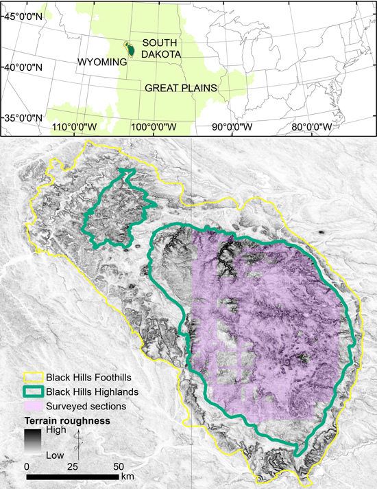
Fig. 1. The Black Hills in South Dakota and Wyoming, USA, is an area of mountainous topography (terrain roughness displays elevation steepness) embedded within the Great Plains grasslands of the central United States. The Black Hills is comprised of the Black Hills Foothills and Highlands ecological subsections. The study extent is the area with available records of tree surveys in South Dakota (purple).
Historical information is available for various parts of the Black Hills before and during Euro-American settlement, with accompanying logging and farming land uses that changed forests. Federal government expeditions, e.g., the Warren Expedition of 1857 (Warren 1875), the Raynolds Expedition of 1859–1860 (McLaird and Turchen 1973), the Custer Expedition of 1874 (McLaird and Turchen 1974b), and the Dodge Expedition of 1875 (Newton and Jenny 1880; Kime 1996) report general conditions, encompassing areas burned by fire, blown down timber, dense stands of larger (20 to 30 cm) diameter pine trees, and scattered pine groves (Newton and Jenny 1880; Kime 1996). The first comprehensive assessment of the forests of the Black Hills occurred 25 years after Euro-American settlement. Graves (1899) recorded tree counts by size class for 0.2 and 0.4 ha plots, resulting in a density estimate of 135 trees ha–1 (see details below). Graves (1899) also described a large amount of open land covered by grass, mountain prairies, and parks, and a variety of tree densities, diameters, and ages, but incorporating stands that contained a high density of seedlings and saplings; he attributed the open landscape to fire. Moreover, the Black Hills were less covered by trees during 1874 than today based on photographic comparisons to the 1874 Custer Expedition (William H. Illingworth photos available from the South Dakota State Historical Society, Pierre, SD; Progulske and Sowell 1974; Horsted 2006).
Modern reconstructions and dendrochronological studies have examined forests of the Black Hills. Based on different accounts (i.e., historical records, photographs, and dendrochronological studies), Shinneman and Baker (1997) concluded that large stand-replacing disturbances such as fire, tornados, and insect infestations produced patches of dense, even aged trees with closed canopies and that these were more common in the northern and central Black Hills. In the southern Black Hills and on south-facing slopes, trees were more widely spaced, probably the result of low-severity, surface fires, which eliminated downed fuel and understory vegetation. The tallest, oldest stands were restricted to canyon bottoms and other protected areas. Brown and Cook (2006) reconstructed historical forests using trees aged pre-1900 to determine that the Black Hills consisted of a landscape mosaic that ranged from non-forested patches and open stands of large trees to dense stands with many similar-sized and -aged trees. Stumps dated to 1900 were significantly larger in diameter than live trees of similar mean ages that were measured in 1999 (Brown and Cook 2006). Correlation between climate data and fire scars showed that dense, even-aged stands resulted from large areas of fires that were prevalent during prolonged periods of drought followed by long wet periods with copious recruitment of individuals (Brown 2006).
To provide another line of evidence approximating historical forests, we used GLO surveys of tree species, diameter, and distance recorded in a point-centered quarter method that were conducted during years 1878 to 1915 (Fig. 2) in the Black Hills Highlands of South Dakota (Fig. 1; Cleland et al. 2007). Our data are samples drawn from the entire area instead of selected stands and thus represent the landscape. While the GLO surveys were not completed before Euro-American settlement, the derived quantitative and qualitative documentation supply an ecological reference for the historical composition and structure of ponderosa pine forests in the Black Hills and the western United States in general. Our formal questions were: What was the historical tree composition and associated diameter size compared to current composition and diameters in the Black Hills, and what was the historical tree density of the Black Hills and how does that compare to current tree density?
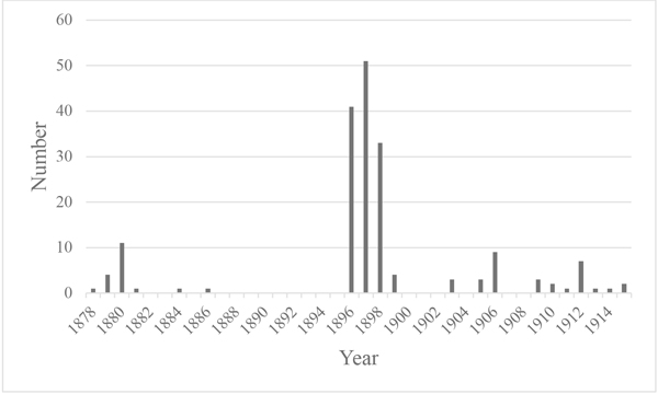
Fig. 2. Number of General Land Office surveys by year in the Black Hills, South Dakota, USA.
2 Methods
2.1 Study area
Crossing the South Dakota-Wyoming border, the Black Hills form an oval dome, extending about 200 km in a north-south direction and about 75 km in an east-west direction (Froiland 1978) above the surrounding grasslands (Fig. 1). The mountains were created by several uplifts during the Laramide orogeny, resulting in several, distinct geomorphic features (Feldman and Heimlich 1980). Our study area of the Black Hills Highlands includes the following geomorphic features: the Limestone Plateau and Minnelusa Foothills, comprised of limestones, sandstones, and shales, and the Central Crystalline Core, a rugged, rocky area made up of metamorphic and igneous rocks (Froiland 1978). The Black Hills Highlands have a mean elevation of 1630 m, ranging from 1030 m to 2190 m. The grasslands at the base of the Black Hills have a mean elevation of 1050 m, ranging from 640 m to 1515 m.
2.2 Tree surveys and composition
The General Land Office originated during the year 1812 to direct surveys of the Public Land Survey System (founded in the year 1785) of townships and ranges, based on 1 mile (0.8 km) square sections. Surveyors recorded species, diameter, distance, and bearing of two to four trees in a point-centered quarter method every 0.8 km at the corners and middle of each section line (White 1983). We recorded 6580 survey points in the South Dakota Black Hills Highlands (Fig. 1) from scanned field notes (South Dakota State Historical Society 2021). The points, surveyed from 1878 to 1915, contained 10 776 trees with diameters ≥12.7 cm at 1.37 m height above ground level after excluding 475 smaller trees. About 35% of survey points did not have trees recorded due to distances to nearest trees exceeding 60 meters.
The United States Department of Agriculture Forest Service Forest Inventory and Analysis (FIA; Bechtold and Patterson 2005; Forest Inventory and Analysis 2021) has long-term forest plots located about every 2400 ha across the country. Each plot contains four 7.31-m radius subplots configured as a central subplot surrounded by three outer subplots. Plots typically are visited every five to ten years. We used a complete cycle of surveys from years 2011 to 2016 in the South Dakota Black Hills Highlands, representing 3425 trees (diameters ≥12.7 cm at 1.37 m height).
For both datasets, we determined composition, or percent of all trees, and mean and maximum diameter for each species. Although pine species were not differentiated, aside from ponderosa pine, only localized, small stands of lodgepole pine (Pinus contorta Douglas ex Louden) and limber pine (P. flexilis E. James) are present (Rogers 1969). The GLO records were not a complete census or a random sample; rather, surveyors selected trees of medium diameter that were sound (White no date; Grimm 1984; Powell 2008). This is helpful for characterizing midstory and overstory trees (diameters ≥12.7 cm), but we recognize that the historical distribution of trees may have contained a greater percentage of larger trees due to more limited sources of overstory disturbance before the advent of steam-powered sawmills. Regarding smaller diameter trees, we compared only truncated (≥12.7 cm) samples.
2.3 Historical density
Uncertainty occurs in density estimates from GLO surveys despite systematic, comprehensive surveys, and we therefore rely on historical accounts to support results. Surveys follow the point-centered quarter method, where each survey point was delineated into four equal quarters by cardinal directions, but density estimates from this method are not as accurate as from plot surveys (Hanberry et al. 2011). Density estimates from the Morisita plotless estimator (Morisita 1957) are probable to be within ±10% of the true density but require simple correction factors for overestimation based on the number of trees per survey points and the potential spatial pattern (Hanberry et al. 2011; Hanberry et al. 2020). Accuracy within ±10% of the true density also depends on if sample sizes are at least 2000 survey points for two trees and 1000 points for three trees (after removal of the most distant tree) and if selected trees are the nearest trees (Hanberry et al. 2011; Hanberry et al. 2012). Trees were not randomly sampled because surveyors did not always select the nearest tree due to survey instructions and personal decisions. When recorded trees are more distant than the nearest trees, density is underestimated (Hanberry et al. 2012). Adjustments give some indication of the magnitude of bias, with the range of potential densities from corrected estimates for clustering, which results in reduced density estimates, and maximum adjustment in estimates for surveyor bias, which increases density estimates. Likely on a landscape, the full range of densities will occur.
We estimated density for the point-centered quarter surveys with the Morisita plotless estimator (Morisita 1957) by the number of trees per point (i.e., angle order). For survey points with four trees, we removed the most distant point because the wide-ranging density estimates for a clustered spatial pattern mean estimates are not likely to fall within ±10% of the true density (Hanberry et al. 2011), resulting in points with three trees. We adjusted (decreased) the density for points with two trees and points with three trees (Hanberry et al. 2011). We next produced low and high density values based on corrections for potential clustered and regular spatial patterning (i.e., random patterning does not require correction; Hanberry et al. 2011). Indeed, ponderosa pine often regenerates densely in clusters. We then adjusted (increased) the low and high density values to account for surveyor bias (Hanberry et al. 2012). For bias adjustment, we determined the frequencies for quadrant location, quadrant configuration, and azimuth and corrected for non-random frequencies by finding the adjustment quotient from regression equations (Hanberry et al. 2012). The mean density value was a simple mean of the final low and high densities. We also calculated tree basal area based on the quadratic mean diameter. To estimate landscape density, including the 36% of points with no trees, we computed an average of the mean densities of points with two trees, points with three trees, and points with no trees weighted by number of points.
For another historical comparison of density, we calculated tree density (minimum average tree diameter 15.2 cm) from Graves’ (1899: 99–156) plots. Although he did not specify the criteria used to select plots, seventy ½-acre and 1-acre (0.2-ha and 0.4-ha) plots spanned eleven watersheds in the South Dakota Black Hills and included only forested sites. At each plot, he paced the boundary of the sampling area, counted trees, and estimated their diameters. From his data, we included merchantable trees, other trees, and cut stumps.
2.4 Current density
From FIA surveys, we selected plots with at least two trees (i.e., trying to reduce the potential influence of clearcutting) and 100% forestland, which is defined as “land that is at least 10 percent stocked by forest trees of any size, or land formerly having such tree cover, and not currently developed for a nonforest use” (Bechtold and Patterson 2005: 80). We calculated density for each plot by summing the tree expansion factor of 6.018 based on one tree representing the inverse of the plot area. After determining the mean density for all plots, we calculated the basal area from the quadratic mean diameter.
3 Results
For composition, or percent of all trees (diameters ≥12.7 cm at 1.37 m height), ten species were shared by the historical GLO and current FIA surveys (Table 1). Ponderosa pine was the dominant species in both datasets but decreased over time from 95.4% to 86.2% of all trees, with a consequent increase in most non-pine species. White spruce notably increased from 1.5% to 6.7% of all trees. Of ponderosa pine, white spruce, quaking aspen, and bur oak, which were the only species that were ≥1% of all trees, ponderosa pine and bur oak trees currently are smaller in mean diameter by 7.4 cm and 10.2 cm than historically, respectively, while white spruce and quaking aspen trees are larger in mean diameter by 2.4 cm and 3.9 cm than historically. Mean ponderosa pine diameters decreased from 30.6 cm to 24.7 cm over time, while maximum diameter reduced from 121.9 cm to 71.6 cm over time.
| Table 1. Composition and diameter of trees (diameters ≥12.7 cm at 1.37 m height) for historical (years 1878 to 1915) and current (years 2011 to 2016) surveys in the South Dakota Black Hills, USA. | ||||||||
| Species | Historical | Current | ||||||
| Composition | Diameter (cm) | Composition | Diameter (cm) | |||||
| Count | Percent | Mean | Max | Count | Percent | Mean | Max | |
| Pinus ponderosa P. Lawson & C. Lawson (ponderosa pine) | 10 284 | 95.4 | 31.3 | 121.9 | 2950 | 86.2 | 23.9 | 70.1 |
| Picea glauca (Moench) Voss (white spruce) | 157 | 1.5 | 21.8 | 76.2 | 228 | 6.7 | 24.1 | 54.6 |
| Populus tremuloides Michx. (quaking aspen) | 155 | 1.4 | 15.5 | 30.5 | 93 | 2.7 | 19.4 | 36.8 |
| Quercus macrocarpa Michx. (bur oak) | 142 | 1.3 | 26.5 | 91.4 | 71 | 2.1 | 16.2 | 29 |
| Betula papyrifera Marshall (paper birch) | 16 | 0.1 | 14.9 | 20.3 | 29 | 0.8 | 15.9 | 20.8 |
| Juniperus scopulorum Sarg. (Rocky Mountain juniper) | 8 | 0.1 | 22.5 | 30.5 | 22 | 0.6 | 19.6 | 34.3 |
| Ulmus americana L. (American elm) | 7 | 0.1 | 30.5 | 45.7 | 2 | 0.1 | 19.4 | 20.6 |
| Celtis occidentalis L. (hackberry) | 4 | 0 | 15.2 | 15.2 | 1 | 0 | 17 | 17 |
| Acer negundo L. (box elder) | 1 | 0 | 17.8 | 17.8 | 0 | 0 | 0 | 0 |
| Populus deltoides W. Bartram ex Marshall (plains cottonwood) | 1 | 0 | 27.9 | 27.9 | 0 | 0 | 0 | 0 |
| Fraxinus pennsylvanica Marshall (green ash) | 0 | 0 | 0 | 0 | 27 | 0.8 | 17.9 | 37.1 |
The tree density estimate from points with two trees was about 74 trees ha–1 and from points with three trees was about 154 trees ha–1 (Table 2). The 135 trees ha–1 calculated from Graves’ (1899) data falls between our two density estimates calculated from GLO data, albeit the tree diameter threshold was smaller for the GLO records (diameters ≥12.7 cm) than Graves’ plots (diameters ≥15.2 cm). Densities between the survey points with two trees and the points with three trees diverged due to different number of points, which means a greater or lesser coverage and accuracy, different locations, clumping effects, and influence of lack of trees. Although about 35% of survey points did not have recorded trees, those survey points with recorded trees were not necessarily forested; that is, the survey points may be in grasslands near trees. Indeed, densities indicated the open structure of savannas and woodlands, with densities ranging from 66 trees ha–1 for survey points with two trees and a clustered pattern, to 162 trees ha–1 for survey points with three trees and a regular pattern. These estimates are for points that cover the landscape to have enough samples for an accurate estimate, rather than reflecting any intentional environmental gradient.
| Table 2. Density (trees ha–1; diameters ≥12.7 cm at 1.37 m height) and basal area (BA = basal area in m2 ha–1; diameters ≥12.7 cm) from historical surveys, for survey points with two trees or survey points with three trees (i.e., the fourth tree removed) and unadjusted and adjusted for surveyor bias and density from current surveys in the South Dakota Black Hills, USA. | |||||
| Survey | Density (unadjusted) | Density | Density low | Density high | BA |
| Historical, points with two trees | 84 | 74 | 66 | 82 | 6.9 |
| Historical, points with three trees | 137 | 154 | 146 | 162 | 13.5 |
| Current | 311 | 277 | 345 | 15.4 | |
The entire landscape mean density was 62 trees ha–1, taking into account grassland points with no trees (i.e., 35% of historical survey points did not record any trees), savanna points with two trees (savanna densities ranging from 50 to 100 trees ha–1, as defined in Hanberry et al. 2014a), and open woodland points with three trees (open woodland densities ranging from 100 to 175 trees ha–1). In addition to tree data, GLO surveyors also included brief narratives about the vegetation, or fields, houses, and cut stumps. At various points these notes described changes in the vegetation encountered, including: dense timber, heavy timber, medium timber, scattering timber, scattering stunted pine, no timber, second growth, and timber burnt and fallen. Thus, their notes depict a variety of structure.
In contrast, current mean tree density was 311 trees ha–1, which represents a doubling to quadrupling of density over time. These greater densities generally represent closed forests, which are comprised of high tree densities throughout the vertical profile, particularly with dense understory and midstory tree layers that are not controlled by fire and ultimately result in dense trees in the overstory. Because tree densities were greater, without a great offset by historical diameters compared to current diameters, mean basal area also was greater in current forests (15.4 m2 ha–1) than historical forests (6.9–13.5 m2 ha–1).
4 Discussion
4.1 Natural range of variation
Tree densities, particularly of surface fire-sensitive tree species, have increased throughout U.S. forests following the front of Euro-American settlement (Keane et al. 2002; Reynolds et al. 2013; Addington et al. 2018). In the Black Hills of South Dakota, tree density has increased two- to more than four-fold between historical (years 1878 to 1915) and current (years 2011 to 2016) tree surveys. Historical estimates for the Black Hills from the GLO surveys averaged 74 trees ha–1 (savannas) to 154 trees ha–1 (open woodlands), with variation around each estimate for survey points with trees (diameters ≥12.7 cm). Graves’ (1899) forested plots with densities of 135 trees ha–1 (diameters ≥15.2 cm) helped support GLO density estimates, while photographic sequences recorded lesser tree densities in the past than today (Progulske and Sowell 1974; Horsted 2006).
Surface fire-tolerant ponderosa pine historically was the dominant species, at 95% of all trees, which meant that other tree species were uncommon. In combination with few native tree species in a grassland matrix, only a small increase in non-pine composition was likely to occur with doubling to quadrupling of densities. Pines were most abundant and thus were likely first to increase in density, followed by expansion and in-filling by less common tree species. Composition of pine decreased to 86% of all trees, with an accompanying increase specifically in white spruce from 1.5% to 6.7% of all trees. Ponderosa pine is the commercial species in this region, rather than spruce (Graham et al. 2021); that is, spruce increases are not due to spruce plantations. Additionally, compositional differences are not due to different survey methods. While surveys that employ different methods at slightly different locations and intervals will produce measurements that are not identical, composition remains relatively similar for different survey types within pre-Euro-American landscapes and within current landscapes (e.g., Hanberry et al. 2014b for historical surveys; Hanberry et al. 2020 for current surveys). Analogous changes between historical and current composition and density were quantified for ponderosa pine forests in the central Rocky Mountains of Colorado and Wyoming (Battaglia et al. 2018), the northern Rocky Mountains (Naficy et al. 2010), central Idaho (Sloan 1998), Oregon (Hagmann et al. 2013; Hanberry et al. 2020), the southern Sierra Nevada Mountains (Stephens et al. 2019), and the Southwest (Cooper 1960; Fulé et al. 1997; Moore et al. 2004).
A mosaic of densities occurs in ponderosa pine landscapes, including the open Black Hills region that varied at fine scales from openings of grassland plants to dense stands of trees. Total landscape density was 62 trees ha–1, after accounting for 35% of survey points with no recorded trees. Some of the survey points with no trees may have been due to logging and clearing because logging in some locations had left no timber of commercial value by the time the Black Hills were surveyed, as described in the earliest (1878) GLO surveys (Book 299, South Dakota State Historical Society 2021). In fact, cut stumps were used as bearing trees at approximately 1% of the survey points. Nonetheless, historical accounts and surveyor notes described the range of structure from grasslands to closed, dense stands. Dodge wrote the following about the forests as they appeared in 1875: “I estimate that there are in the two sections over four thousand square miles [10 360 sq. km] of country more or less covered with pine. Of this … I estimate that four tenths are entirely without timber. Another four tenths is composed of young forests… and one tenth is good timber” (quote from Dodge 1876: 102 in Newton and Jenny 1880: 324). Further support for this comes from Graves (1899) who described the forests of the Black Hills during 1897, about 23 years after Euro-American settlement: “The original forest, uninfluenced by fire or windfalls, is found in but few places in the Black Hills. It is found chiefly along streams, in ravines and canyons, at the heads of creeks and side draws, and on protected flats and lower slopes. The forest as it appears today, irregular and broken, composed in many places of defective and scrubby trees, does not represent what the yellow pine is capable of producing. There are trees of every age and size, and there are large areas where there are no trees at all. For a pure forest the merchantable timber is exceedingly small. The natural forest of yellow pine is dense and composed of trees of about the same age. It often comes up in even age stands, and the irregular uneven-aged condition as now found is entirely due to external influences” (Graves 1899: 73–74).
Larger tree diameters also occurred in historical forests according to the GLO surveys compared to current forests. Although surveyors were instructed to record trees with moderate diameters rather than larger trees that may be nearing the end of their life span, the reduced diameter is logical given that increased removal of overstory trees for forest products or land uses has occurred since Euro-American settlement (Freeman 2015). Dendrochronological studies corroborate the presence of larger trees historically than current trees (Brown and Cook 2006). Historical accounts also noted large trees. For example, the geologist F.V. Hayden, who visited the Black Hills on several occasions between 1855 and 1866, estimated: “From one-third to one half of the Black Hills are covered with an abundant growth of young, thrifty pine, many trees from three to four feet [0.9 to 1.2 m] in diameter, and from eighty to one hundred feet [24 to 30 m in height] without a limb” (quote in McLaird and Turchen 1974a: 192). Newton and Jenny (1880) wrote: “On bottomlands in the lower valley of French Creek specimens of this pine [ponderosa pine] were fully 100 feet [30 m] in height, and would measure 35–40 inches [89–102 cm] through at the ground. Trees of these large dimensions are, however, rare in the Hills. Timber from 12–24 inches [30–61 cm] in diameter is common, while extensive tracts are covered by dense forest of small slender pines from 50 to 60 feet [15 to 18 m] high, and rarely less than 8 [20 cm] or more than 12 inches [30 cm] through at the ground.”
4.2 Historical fires
Open forests comprised of fire-tolerant species are maintained by the mechanism of frequent surface fires. Ponderosa pine is tolerant of frequent surface fires and has traits for longevity, living up to 600 years, rather than response traits to relatively frequent stand-replacing disturbance. Fire-tolerant traits include 1) self-pruning of lower branches that raises the crown above low severity flame lengths, 2) thick bark that protects the cambium from heat damage, and 3) long needles that when accumulated on the forest floor promote fires (Keely 2012). Because of this suite of traits, low severity fire does not damage large trees, but reduces recruitment of younger trees (Battaglia et al. 2009). We were not able to describe small diameter trees, but the presence of 35% of historical survey points without trees attests to the competitiveness of herbaceous plants against understory trees, which are typically controlled by frequent surface fires and to some extent by herbivores.
Frequent fires were observed by early Euro-American residents (Gartner and Thompson 1973), although high severity events were rare (Parrish et al. 1996). Historical accounts did report extensive signs of fires, and dense stands may have torched, but high-severity fire cannot spread extensively across open landscapes without trees to carry long flame lengths. Preceding disturbances such as wind events that create windthrows and add to surface fuels may have increased fire severity. Dodge, who traversed the Black Hills in 1875, wrote: “In the foothills & low valleys there are very fair pines, some two feet in diameter & probably twenty ft to the limbs. On the high hills it is very small, & is besides wind-shaken. Fires have made huge rifts through it & we travelled for about four miles through a mass of blown down trees from three in[ches] to a foot in diameter” (quote in Kime 1996: 68). That a “cyclone” had toppled trees was reported by GLO surveyors in the same vicinity (T2S, R3E) in 1899 (Book 07, South Dakota State Historical Society 2021). Of their 1875 survey of the Black Hills, the geologist H. Newton and the mining expert W.P. Jenny (Newton and Jenny 1880: 322) wrote: “The Black Hills have been subjected in the past to extensive forest fires, which have destroyed the timber over considerable areas. Around Custer Peak and along the limestone divide, in the central portions of the Hills, on the headwaters of the Box Elder and Rapid Creeks, scarcely a living tree is to be seen for miles. Some portions of the parks and valleys, now destitute of trees, show by the presence of charred and decaying stumps, that they were once covered by forests.”
The Black Hills region primarily had a frequent surface fire regime, which maintained grasslands and open forests across the landscape. This conclusion is based on 1) survey points with no trees, preponderance of fire-tolerant ponderosa pine, and low historical densities from GLO surveys, 2) Euro-American settlement documentation, encompassing Graves (1899) and GLO surveyor notes, and 3) fire reconstructions of surface fire frequencies every 10 to 35 years (Fisher et al. 1987; Brown and Sieg 1996; Brown et al. 2000; Brown et al. 2008). Occasional, high severity fires occurred in dense stands, as detailed in historical accounts and fire chronologies. Wildlife species, such as black-backed woodpeckers [Picoides arcticus (Swainson, 1832)], which depend on dense stands and fire-damaged trees (Rota et al. 2014) also are indicators that appropriate conditions occurred historically. However, the open ecosystems around embedded stands provide a natural firebreak to severe fires. Grasslands do not contain canopies to allow spread of fires with long flame lengths, whereas savannas and open woodlands have limited clustering of trees, confining fire to torching of single or grouped trees.
4.3 Fire exclusion
Fire exclusion occurs through a combination of two primary factors. The first is land cover change from herbaceous vegetation that supports frequent fires to various land uses such as roads, harvested fields, grazed fields and forests that do not readily carry fire due to limited fine fuels, and also transition to dense, closed forests that do not have appropriate fuels or environmental conditions to carry frequent surface fire. The second factor is a change from a culture that uses fire as a management tool to one that views fire as a disturbance that should be suppressed. For example, during the early 1900s, the U.S. Congress passed the Weeks Act, which directed federal foresters to provide fire protection for forests (Pyne 1997).
The effectiveness of fire control is evidenced by increased mean fire interval in the Black Hills since Euro-American settlement (Brown et al. 2000; Brown and Sieg 1996, 1999). As a consequence, trees have become more dense without control of tree regeneration by frequent surface fires, and fire-sensitive species have increased, particularly spruce (Table 1), which has dense limb growth near the forest floor. Thus, fire suppression, in part, has contributed to high density stands with surface to crown continuity of fuels, so that while the probability of high severity fires has increased, the probability of frequent surface fires has decreased.
The convergence of fuel accumulation due to fire exclusion, harvesting of larger fire-resistant tree species that results in decreased canopy base height and increased surface and ladder fuels by releasing regeneration, and increased extreme fire weather days may result in high severity fires more often and over larger areas especially in stands with high stocking rates, fuels, and surface to crown fuel connectivity. Frequently harvested forests with a structure of many small diameter trees, such as in the current structure of the Black Hills (Graham et al. 2021), have been documented to burn more severely than forests with a structure that has a high canopy base height and limited surface and ladder fuels (Zald and Dunn 2018; Jain et al. 2020). Moreover, as climate change continues, extreme fire weather is predicted to increase (Barbero et al. 2015; Hanberry 2020). High severity fire will consume organic matter, killing the roots and their symbionts, negatively impacting soil structure and function (Graham and Jain 2005). In contrast, frequent surface fires may result in roots and symbionts at protected depths in forest soils where they remain unaffected by fire (Graham and Jain 2005).
4.4 Other costs of current forest structure
Species are less tolerant of additional stresses when already under stress from one factor, such as high-density stands. Because natural thinning of ponderosa pine proceeds slowly (Boldt and Van Deusen 1974), stands with high density of seedlings will develop into stands with high-density of saplings and poles. In high-density stands, trees may have slender stems, poorly developed root systems, and asymmetrical crowns, resulting in greater susceptibility to snow bending and breakage in saplings and pole-size trees and wind damage in pole- to small saw-size trees, relative to lower density stands (Boldt and Van Deusen 1974).
Trees will be weakened by competition for resources, such as water. Indeed, greater tree coverage typically results in greater stand water use and loss of more water through evapotranspiration compared to stands with lesser tree coverage, consequently lowering the water table (Parrish et al. 1996). Parrish et al. (1996) reported reductions in water yields and perennial streams in the Black Hills due to increased tree densities, control of beavers (Castor canadensis Kuhl, 1820), and increased water use for human activities. Evapotranspirational water losses increase with temperature and are expected to increase with climate change. Drought weakens trees, particularly in high-density stands (Bottero et al. 2017). Both temperature (+0.45 °C) and precipitation (+5.7 cm) have increased in the Black Hills during the past 40 years (1981–2020) compared to 1895–1980 (PRISM Climate Group 2022), but extreme events, such as droughts, also have increased with climate change (Hanberry 2020).
Low densities of overstory trees and basal areas are well-verified to reduce vulnerability to insect outbreaks (Graham et al. 2019). Trees under stress will generate poor resin flow, making them more prone to beetle infestation (Boldt and Van Deusen 1974). Recent outbreaks by mountain pine beetles (Dendroctonus ponderosae Hopkins, 1902) and other insects that cause tree mortality may be outside of historical bounds, in that historically insects occurred in low numbers, killing weak trees with rare outbreaks (Romme et al. 2006). Warming additionally has allowed mountain pine beetles to erupt at higher elevations and latitudes where winters historically were cold enough to reduce over-wintering insect survival (Milton and Ferrenberg 2012). Consequently, insect outbreaks may be due to a combination of climate change (i.e., drought-stressed trees, warm summers that accelerate insect growth and development, and warm winters that allow insect larvae to survive) and land use change that produces trees with reduced vigor in dense forests (Romme et al. 2006). Thinning trees will promote growth and reduce mortality under beetle attacks, especially during droughts (Tepley et al. 2020; Negron et al. 2016).
Management to reduce tree densities has been well-described (Shepperd and Battaglia 2002; Fitzgerald 2005; Hunter et al. 2007; Thom 2010; Bragg et al. 2020). Objectives may encompass restoration and maintenance of compositional, structural, and functional ecosystem elements, ecological integrity, reduction of fire hazard, and reduction of risk for insect outbreaks. Additional goals may include resistance and resilience to climate change, such as warming temperatures and rapid development of drought (i.e., flash droughts due to unusually low precipitation combined with unusually high temperatures, wind speeds, and solar radiation). Prescribed burning, thinning, and masticating, either alone or in combination, are options after determining goals.
5 Conclusions
Historical tree surveys during Euro-American settlement offer information about the natural range of variations. Although the Black Hills landscape overall was savannas and woodlands, the spectrum from grasslands to dense stands occurred historically. In historical forests, fire-tolerant ponderosa pine was 95% of all trees. In the absence of surface fires which reduce small-diameter trees, tree densities increased two- to four-fold, and fire-sensitive species, particularly white spruce, increased relative to ponderosa pine. Benefits of reducing tree density and increasing tree diameters include support of biodiversity and reduction of fire severity, insect outbreaks, and water demand.
Acknowledgements
We thank M. Battaglia and reviewers for reviewing the manuscript. This research was supported by the USDA Forest Service, Rocky Mountain Research Station. The findings and conclusions in this publication are those of the authors and should not be construed to represent any official USDA or U.S. Government determination or policy. The authors have no conflicts of interest.
Declaration of openness of research materials, data, and code
The General Land Office data are located at the South Dakota State Historical Society, South Dakota Digital Archives, GLO Land Survey Field Notes. https://sddigitalarchives.contentdm.oclc.org/digital/collection/p15914coll1.
Authors contributions
Robert E. Tatina: data transcription, writing original draft, review and editing, final approval.
Brice B. Hanberry: conceptualization, data analysis and interpretation, writing original draft, review and editing, final approval.
Funding
No funding was provided.
References
Addington RN, Aplet GH, Battaglia MA, Briggs JS, Brown PM, Cheng AS, Dickinson Y, Feinsteinn JA, Pelz KA, Regan CM, Thinnesn J, Truex R, Fornwalt PJ, Gannon B, Julian CW, Underhill JL, Wolk B (2018) Principles and practices for the restoration of ponderosa pine and dry mixed-conifer forests of the Colorado Front Range. RMRS-GTR-373, USDA Forest Service. Rocky Mountain Research Station, Fort Collins, CO. https://doi.org/10.2737/RMRS-GTR-373.
Barbero, R., Abatzoglou JT, Larkin NK, Kolden CA, Stocks B (2015) Climate change presents increased potential for very large fires in the contiguous United States. Int J Wildland Fire 24: 892–899. https://doi.org/10.1071/WF15083.
Battaglia M, Smith FW, Shepperd WD (2009) Predicting mortality of ponderosa pine regeneration after prescribed fire in the Black Hills, South Dakota, USA. Int J Wildland Fire 18: 176–190. https://doi.org/10.1071/WF07163.
Battaglia MA, Gannon B, Brown PM, Fornwalt PJ, Cheng AS, Huckaby LS (2018) Changes in forest structure since 1860 in ponderosa pine dominated forests in the Colorado Front Range, USA. Forest Ecol Manag 422: 147–160. https://doi.org/10.1016j.foreco.2018.04.010.
Bechtold WA, Patterson PL (2005) The enhanced forest inventory and analysis program—national sampling design and estimation procedures. SRS-80, USDA Forest Service, Southern Research Station, Asheville, NC. https://doi.org/10.2737/SRS-GTR-80.
Boldt CE, Van Deusen JL (1974) Silviculture of ponderosa pine in the Black Hills: the status of our knowledge. RM-124, USDA Forest Service, Rocky Mountain Research Station, Fort Collins, CO. https://doi.org/10.5962/bhl.title.99203.
Bottero A, D’Amato AW, Palik BJ, Bradford JB, S Fraver S, Battaglia MA, Asherin LA (2017) Density‐dependent vulnerability of forest ecosystems to drought. J Appl Ecol 54: 1605–1614. https://doi.org/10.1111/1365-2664.12847.
Bragg DC, Hanberry BB, Hutchinson TF, Jack SB, Kabrick JM (2020) Silvicultural options for open forest management in eastern North America. Forest Ecol Manag 474, article id118383. https://doi.org/10.1016/j.foreco.2020.118383.
Brown PM (2006) Climate effects on fire regimes and tree recruitment in Black Hills ponderosa pine forests. Ecology 87: 2500–2510. https://doi.org/10.1890/0012-9658(2006)87[2500:CEOFRA]2.0.CO;2.
Brown PM, Cook B (2006) Early settlement forest structure in Black Hills ponderosa pine forests. Forest Ecol Manag 223: 284–290. https//doi.org/10.1016/j.foreco.2005.11.008.
Brown PM, Sieg CH (1996) Fire history in interior ponderosa pine communities of the Black Hills, South Dakota, USA. Int J Wildland Fire 6: 97–106. https://doi.org/10.1071/WF9960097.
Brown PM, Sieg CH (1999) Historic variability in fire at the ponderosa pine-Northern Great Plains prairie ecotone. Ecoscience 6: 539–547. https://doi.org/10.1080/11956860.1999.11682563.
Brown PM, Wienk CL, Symstad AJ (2008) Fire and forest history at Mount Rushmore. Ecol Appl 18: 1984–1999. https://doi.org/10.1890/07-1337.1.
Brown, PM, Ryan MG, Andrews TG (2000) Historical fire frequency in research natural areas, central Rocky Mountains and Black Hills. Nat Area J 20: 133–139.
Cleland DT, Freeouf JA, Keys JE, Nowacki GJ, Carpenter CA, McNab WH (2007) Ecological subregions: sections and subsections for the conterminous United States. WO-76D, USDA Forest Service, Washington, DC. https://doi.org/10.2737/WO-GTR-76D.
Cooper CF (1960) Changes in vegetation, structure and growth of southwestern pine forests since white settlement. Ecol Monogr 30: 129–164. https://doi.org/10.2307/1948549.
Covington WW, Moore MM (1994a) Changes in multiresource conditions in ponderosa pine forests since Euro-American settlement. J For 92: 39–47.
Covington WW, Moore MM (1994b) Post-settlement changes in natural fires regimes and forest structure: ecological restoration of old growth ponderosa pine forests. J Sustain For 2: 153–181. https://doi.org/10.1300/J091v02n01_07.
Dodge RI (1876) The Black Hills. James Miller and Company, New York, NY.
Feldman R, Heimlich R (1980) The Black Hills. Kendall/Hunt Publishing Company. Kent State University, Kent, OH.
Fisher RF, Jenkins MJ, Fisher WF (1987) Fire and the prairie-forest mosaic of Devils Tower National Monument. Am Midl Nat 117: 250–257. https://doi.org/10.2307/2425966.
Fitzgerald SA (2005) Fire ecology of ponderosa pine and the rebuilding of fire-resilient ponderosa pine ecosystems. In: Ritchie MW, Maguire DA, Youngblood A (tech coord) Proceedings of the symposium on ponderosa pine: issues, trends, and management, 2004 October 18–21, Klamath Falls, OR. PSW-GTR-198, USDA Forest Service, Pacific Southwest Research Station, Albany, CA, pp 197–225.
Freeman JF (2015) Black Hills forestry: a history. University Press of Colorado, Boulder, CO. https://doi.org/10.5876/9781607322993.
Froiland SG (1978) Natural history of the Black Hills. Center for Western Studies, Augustana College, Sioux Falls, SD.
Fulé P, Covington WW, Moore MM (1997) Determining reference conditions for ecosystem management of southwestern ponderosa pine forests. Ecol Appl 7: 895–908. https://doi.org/10.2307/2269441.
Gartner FR, Thompson WW (1973) Fire in the Black Hills forest-grass ecotone. In: Proceedings annual tall timbers fire ecology Conference, Lubbock, TX, pp 37–68.
Graham RT, Asherin LA, Jain TB, Baggett LS, Battaglia MA (2019) Differing ponderosa pine forest structures, their growth and yield, and mountain pine beetle impacts: growing stock levels in the Black Hills. RMRS-GTR-393, USDA Forest Service, Rocky Mountain Research Station, Fort Collins, CO. https://doi.org/10.2737/RMRS-GTR-393.
Graham RT, Battaglia MA, Jain TB (2021) A scenario-based assessment to inform sustainable ponderosa pine timber harvest on the Black Hills National Forest. RMRS-GTR-422, USDA Forest Service, Rocky Mountain Research Station, Fort Collins, CO. https://doi.org/10.2737/RMRS-GTR-422.
Graves HS (1899) Black Hills Forest Reserve. Government Printing Office, Washington, DC. https://babel.hathitrust.org/cgi/pt?id=hvd.32044102818671&view=1up&seq=3&skin=2021. Accessed 11 November 2021.
Grimm EC (1984) Fire and other factors controlling the Big Woods vegetation of Minnesota in the mid-nineteenth century. Ecol Monogr 54: 291–311. https://doi.org/10.2307/1942499.
Hagmann RK, Franklin JF, Johnson KN (2013) Historic structure and composition of ponderosa pine and mixed-conifer forests in south-central Oregon. Forest Ecol Manag 304: 492–504. https://doi.org/10.1016/j.foreco.2013.04.005.
Hanberry BB (2020) Compounded heat and fire risk for future US populations. Sustainability 12, article id 3277. https://doi.org/10.3390/su12083277.
Hanberry BB, Fraver S, He HS, Yang J, Dey DD, Palik BJ (2011) Spatial pattern corrections and sample sizes for forest density estimates of historical tree surveys. Landscape Ecol 26: 59–68. https://doi.org/10.1007/s10980-010-9533-7.
Hanberry BB, Yang J, Kabrick JM, Hong HH (2012) Adjusting forest density estimates for surveyor bias in historical tree surveys. Am Midl Nat 167: 285–306. https://doi.org/10.1674/0003-0031-167.2.285.
Hanberry BB, Jones-Farrand DT, Kabrick JM (2014a) Historical open forest ecosystems in the Missouri Ozarks: reconstruction and restoration targets. Ecol Restor 32: 407–416. https://doi.org/10.3368/er.32.4.407.
Hanberry BB, Kabrick JM, He HS (2014b) Changing tree composition by life history strategy in a grassland‐forest landscape. Ecosphere 5, article id 34. https://doi.org/10.1890/ES13-00345.1.
Hanberry BB, Justice DC, Powell DC (2020) Discovering Douglas-fir woodlands in the historical forest of the Umatilla National Forest, eastern Oregon and Washington. Forests 11, article id 1122. https://doi.org/10.3390/f11101122.
Horsted P (2006) The Black Hills yesterday and today. Golden Valley Press, Custer, SD.
Hunter ME, Shepperd WD, Lundquist JE, Andreu MG, Butler JL, Smith FW (2007) A comprehensive guide to fuels treatment practices for ponderosa pine in the Black Hills, Colorado Front Range, and Southwest. RMRS-GTR-198, USDA Forest Service, Rocky Mountain Research Station, Ft. Collins, CO. https://doi.org/10.2737/RMRS-GTR-198.
Jain TB, Abrahamson I, Anderson N, Hood S, Hanberry B, Kilkenny F, McKinney S, Ott J, Urza A, Chambers J, Battaglia M, Varner J, O’Brien J (2021) Effectiveness of fuel treatments at the landscape scale: state of understanding and key research gaps. JFSP PROJECT ID: 19-S-01-2. Joint Fire Sciences Program, Boise, ID.
Keane RE, Ryan KC, Veblen TT, Allen CD, Logan J, Hawkes B (2002) Cascading effects of fire exclusion in the Rocky Mountain ecosystems: a literature review. RMRSGTR-91, USDA Forest Service, Rocky Mountain Research Station, Ft. Collins, CO. https://doi.org/10.2737/RMRS-GTR-91.
Keeley JE (2012) Ecology and evolution of pine life histories. Ann For Sci 69: 445–453. https://doi.org/10.1007/s13595-012-0201-8.
Kime WR (1996) The Black Hills journals of Colonel Richard Irving Dodge. University of Oklahoma Press, Norman, OK.
Ludlow W (1875) Report of a reconnaissance of the Black Hills of Dakota, made in the summer 1874. U.S. Government Printing Office, Washington, DC. http://name.umdl.umich/AFK4434.0001.001. Accessed 11 November 2021.
McLaird JD, Turchen LV (1973) Exploring the Black Hills, 1855–1875: reports of the government expeditions. The explorations of Captain William Franklin Raynolds, 1859–1860. S D History 4: 18−62.
McLaird JD, Turchen LV (1974a) Exploring the Black Hills, 1855–1875: reports of the government expeditions. The scientist in western exploration: Ferdinand Vandiver Hayden. S D History 4: 162−197.
McLaird JD, Turchen LV (1974b) Exploring the Black Hills, 1855–1875: reports of the government expeditions. Colonel William Ludlow and the Custer Expedition, 1874. S D History 4: 282–319.
Milton JB, Ferrenberg SM (2012) Mountain pine beetle develops an unprecedented summer generation in response to climate warming. Am Nat 179: E163–E171. https://doi.org/10.1086/665007.
Moore MM, Huffman DW, Fulé PZ, Covington WW, Crouse JE (2004) Comparison of historic and contemporary forest structure and composition on permanent plots in southwestern ponderosa pine. For Sci 50: 162–176. https://doi.org/10.1093/forestscience/50.2.162.
Morisita M (1957) A new method for the estimation of density by the spacing method applicable to non-randomly distributed populations. Physiology and Ecology 7:134–144. Translation by U.S. Department of Agriculture, Division of Range Management. https://people.hws.edu/mitchell/Morisita1957.pdf. Accessed 11 November 2021.
Naficy C, Sala A, Keeling EG, Graham J, DeLuca T (2010) Interactive effects of historic logging and fire exclusion on ponderosa pine forests in the northern Rockies. Ecol Appl 20: 1851–1864. https://doi.org/10.1890/09-0217.1.
Negron JF, Allen KK, Ambourn A, Cook B, Marchand K (2016) Large-scale thinning, ponderosa pine, and mountain pine beetle in the Black Hills, USA. For Sci 63: 529–536. https://doi.org/10.5849/FS-2016-061.
Newton H, Jenny WP (1880) Report of the geology and resources of the Black Hills of Dakota with atlas. Government Printing Office, Washington, DC. https://archive.org/details/reportongeologyr00geog. Accessed 11 November 2021.
Parrish JB, Herman DJ, Reyher DJ, Gartner FR (1996) A century of change in the Black Hills and riparian ecosystems. Bulletin 726. South Dakota State University, Agricultural Experiment Station, Brookings. http://openprairie.sdstate.edu/agexperimentsta_bulletins/726. Accessed 11 November 2021.
Powell DC (2008) Using General Land Office survey notes to characterize historical vegetation conditions for Umatilla National Forest. White Paper F14-SO-WP-SILV-41. USDA Forest Service, Pacific Northwest Region, Pendleton, OR. https://www.fs.usda.gov/Internet/FSE_DOCUMENTS/stelprdb5413735.pdf. Accessed 11 November 2021.
PRISM Climate Group (2022) Oregon State University. https://prism.oregonstate.edu. Accessed 11 November 2021.
Progulske RR, Sowell RH (1974) Yellow ore, yellow hair, yellow pine: a photographic study of a century of forest ecology. Bulletin 621, Agricultural Experiment Station, South Dakota State University, Brookings, SD. http://openprairie.sdstate.edu/agexperimentsta_bulletins/621. Accessed 11 November 2021.
Pyne SJ (1997) Fire in America: a cultural history of wildland and rural fires. University of Washington Press, Seattle, WA.
Reynolds RT, Sanchez Meador AJ, Youtz JA, Nicolet T, Matonis MS, Jackson PL, DeLorenzo DG, Graves AD (2013) Restoring composition and structure in southwestern frequent-fire forests: a science-based framework for improving ecosystem resiliency. RMRS-GTR-310, USDA Forest Service, Rocky Mountain Research Station, Ft. Collins, CO. https://doi.org/10.2737/RMRS-GTR-310.
Rogers DJ (1969) Isolated stands of lodgepole and limber pine in the Black Hills. Proc S D Acad Sci 48: 138–147.
Romme WH, Clement J, Hicke J, Kulakowski JD, MacDonald LH, Schoennagel TL, Veblen TT (2006) Recent forest insect outbreaks and fire risk in Colorado forests: a brief synthesis of relevant research. Colorado State University, Fort Collins, CO.
Rota CT, Millspaugh JJ, Rumble MA, Lehman CP, Kesler DC (2014) The role of wildfire, prescribed fire and mountain pine beetle infestations on the population dynamics of black-backed woodpeckers in the Black Hills, South Dakota. PLoS ONE 9, article id e94700. https://doi.org/10.1371/journal.pone0094700.
Shepperd WD, Battaglia MA (2002) Ecology, silviculture, and management of Black Hills ponderosa pine. RMRS-GTR-97, USDA Forest Service, Rocky Mountain Research Station, Ft. Collins, CO. https://doi.org/10.2737/RMRS-GTR-97.
Shinneman DJ, Baker WL (1997) Non-equilibrium dynamics between catastrophic disturbances and old-growth forests in Ponderosa pine landscapes of the Black Hills. Conserv Biol 11: 1276–1288. https://doi.org/10.1046/j.1523-1739.1997.96198.x.
Sloan JP (1998) Historic density and stand structure of an old growth forest in the Boise Basin of central Idaho. In: Pruden TL, Brennan LA (eds) Fire in ecosystem management: shifting the paradigm from suppression to prescription. Tall Timbers Fire Ecology Conference Proceedings 20, Tall Timbers Research Station, Tallahassee, Florida, pp 258–266.
South Dakota State Historical Society (2021) South Dakota Digital Archives, GLO Land Survey field notes. https://sddigitalarchives.contentdm.oclc.org/digital/collection/p15914coll1. Accessed 11 November 2021.
Stephens SL, Lyderson JM, Collins BM, Fry DL, Meyer MD (2019) Historic and current landscape scale ponderosa pine and mixed conifer forest structure in the southern Sierra Nevada. Ecosphere 6: 1–63. https://doi.org/10.1890/ES14-00379-1.
Tepley AJ, Hood SM, Keyes CR, Sala A (2020) Forest restoration treatments in a ponderosa pine forest enhance physiological activity and growth under climatic stress. Bull Ecol Soc Am 101, article id e01772. https://doi.org/10.1002/bes2.1772.
Thom D (2010) A landscape restoration strategy for the Black Hills National Forest: an island in the plains. USDA Forest Service. https://fs.usda.gov/internet/FSE_DOCUMENTS/stelprdb160754.pdf. Accessed 11 November 2021.
USDA Forest Inventory and Analysis (2021) https://apps.fs.usda.gov/fia/datamart/CSV/datamart_csv.html. Accessed 30 January 2021. Accessed 11 November 2021.
Warren GK (1875) Preliminary report of explorations in Nebraska and Dakota. Government Printing Office, Washington, DC. https://www.loc.gov/item/rc01001239/. Accessed 11 November 2021.
White CA (1983) A history of the rectangular survey system. US Department of the Interior Bureau of Land Management, Washington DC. https://www.blm.gov//sites/blm.gov/files/histrect.pdf. Accessed 11 November 2021.
White CA (no date) Durability of bearing trees. US Department of the Interior, Bureau of Land Management, cadastral Survey Training Staff. https://www.ntc.blm.gov/krc/uploads/538/Durability_of_Bearing_Tree.pdf. Accessed 11 November 2021.
Zald HS, Dunn CJ (2018) Severe fire weather and intensive forest management increase fire severity in a multi-ownership landscape. Ecol Appl 28: 1068–1080. https://doi.org/10.1002/eap.1710.
Total of 74 references.
Send to email
